
Location Kiev, Ukraine Postal code 01001 | From European Square Length 1.2 km Major cities Kiev | |
 | ||
Former name(s) Wacław Worowski Street (1923-1937), Eichhornstraße (1941-1943) Similar Maidan Nezalezhnosti, Kiev Pechersk Lavra, Saint Sophia's Cathedral, National Museum of the Histor, Golden Gate - Kiev | ||
Ukraine kiev khreschatyk street life part 22
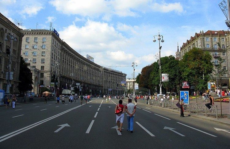
Khreshchatyk (Ukrainian: Хрещатик, Khreshchatyk;) is the main street of Kyiv, Ukraine. The street has a length of 1.3 km (0.81 mi). It stretches from the European Square (northeast) through the Maidan and to Bessarabska Square (southwest) where the Besarabsky Market is located. Along the street are the offices of the Kiev City Council which contains both the city's council and the state administration, the Main Post Office, the Ministry of Agrarian Policy, the State Committee of Television and Radio Broadcasting, the Central Department Store (TsUM), the Besarabka Market, the Ukrainian House, and others.
Contents
- Ukraine kiev khreschatyk street life part 22
- Map of Khreschatyk St Kyiv Ukraine
- History
- Russian Empire
- Revolution
- Interbellum
- World War II
- Soviet Ukraine
- Independent Ukraine
- Attractions
- Significant buildings
- Streets and Squares
- Transportation
- References
Map of Khreschatyk St, Kyiv, Ukraine
The entire street was completely destroyed during World War II by the retreating Red Army troops and rebuilt in the neo-classical style of post-war Stalinist architecture. Among prominent buildings that did not survive were the Kiev City Duma, the Kiev Stock Exchange, Hotel Natsional, and the Ginzburg House. The street has been significantly renovated during the modern period of Ukraine's independence. Today, the street is still significant to administrative and business city organizations, as well as a popular tourist attraction.
As of 2010, Khreshchatyk is included in the Top 20 of most expensive shopping streets in Europe.
History
The name of Khreshchatyk is believed to be derived from the Slavic word krest or khrest (cross). It lies in a valley that is crossed by several ravines. When looked at from above, the valley resembles a cross. A small river, the Khreshchatyk River, a tributary of Kiev's Lybid River, ran along much of the valley, and still runs underground along much of the street.
Russian Empire
For a long time, Khreshchatyk remained an undeveloped ravine between several neighborhoods of Kiev: Podil - the commercial neighbourhood, the Upper City - the administrative neighbourhood, and Pechersk neighbourhood built around the Pechersk Lavra ("Monastery of the Caves").
The development of the area only started in the 19th century. The ravine was filled and accelerating construction quickly followed. By the middle 19th century, Khreshchatyk was developed as Kiev's main thoroughfare in the climate of rapid growth of the city during the Industrial Revolution in Imperial Russia. The street soon became the center of Kiev's commercial life, as the city itself developed into the main commercial center in the Empire's south-west.
In 1892, the first electric tram line in the Russian Empire ran in Kiev and by 1894, the line was extended to Khreshchatyk. The street was served by the tram for about 40 years.
Revolution
During the period of chaos after the Russian Revolution of 1917, many buildings on Khreshchatyk were heavily damaged as the city changed hands many times between Ukrainian, German, Polish, and Bolshevik forces. On May 9, 1920, the Polish army under General Rydz-Smigly celebrated their capture of Kiev by a ceremonial parade on Khreshchatyk. They were driven out by the Bolshevik counter-offensive within weeks.
Interbellum
Between the wars, Khreshchatyk underwent major development and reconstruction. Between 1923 and 1937, the street was named after V.V. Vorovsky, an early Bolshevik diplomat assassinated in Switzerland. In the mid-1930s, the tram lines were deconstructed, and the trams replaced by trolleybuses.
World War II
During World War II, almost every building on the street was mined with explosives by the retreating Red Army troops. In September 1941, after German troops occupied the city, explosions were set off by radio-controlled fuses from over 400 kilometres away. The demolition of over three hundred buildings on Khreshchatyk became the first operation in history where the long-distance radio-controlled explosions were used for military purposes. Much of the surviving historic center of Kiev was demolished. This unprecedented method of warfare caused panic and brought heavy casualties among both the occupiers and city's remaining civilian population.
Under German occupation, the street was renamed Eichhornstrasse, after the German World War I Field Marshal Hermann von Eichhorn supreme commander of Army Group Kiev (Heeresgruppe Kiew) and simultaneously military governor of Ukraine during the previous German occupation, who had been assassinated in Kiev in 1918.)
Soviet Ukraine
Following the war, Khreshchatyk was rebuilt in the 1950s and 1960s. The street was widened to 75-100 meters and new buildings were erected in the Neoclassical Stalinist architectural style. Important buildings of the new ensemble include the City Council House (Kyivrada), the Central Post Office (Poshtamt) and Trade-Union House (Budynok Profspilok).
The street was one of Kiev's first landmarks that was serviced by the Kiev Metro in 1960, (see Khreshchatyk (Kiev Metro)) and was the system's first transfer station when the second line opened in 1976.
On May 1, 1986, a few days after the Chernobyl nuclear accident, Soviet authorities held a traditional May Day parade on Khreshchatyk, in order to "calm people" and "prevent panic" caused by the disaster. Thousands of Kievans, including many children, were exposed to dangerous doses of radiation. All photographs of that celebration have mysteriously disappeared from the National Archives of Ukraine.
In the late 1980s, the porch of the Central Post Office building partially collapsed during heavy rain, killing a dozen people and injuring some. The porch was rebuilt in the following years according to its original design.
On July 24, 1990, the first ceremonial raising of the Ukrainian national flag took place on Khreshchatyk, on the large flagstaff of the Kiev City Council. Due to its central location, the street became the traditional place for political rallies.
Independent Ukraine
Following the dissolution of the Soviet Union and Ukraine becoming independent, the avenue gained a wider context as the central street of the country. During the late 1990s, a complex reconstruction took place, and most of the buildings were cosmetically cleaned up from elements, structurally upgraded and enhanced with colourful illumination. Modern electronic billboards and screens were also installed.
In 2000–01, Khreshchatyk and Maidan Nezalezhnosti, became the centre of the mass protest campaign known as Ukraine without Kuchma. Allegedly to keep the protesters out, the city Mayor (Oleksandr Omelchenko at that time) ordered a major reconstruction of the street, which led to significant rebuilding of Maidan Nezalezhnosti, and construction of two large underground shopping malls.
In the winter of 2004, Khreshchatyk and Maidan Nezalezhnosti became the centre of the main public protests of the Orange Revolution. The protesters' main tent encampment was situated in the street, and many Khreshchatyk buildings served as makeshift feeding and warming sites for the protesters, including the City Council House. In its peak, over a million people from all around Ukraine attended the rally. Late 2013 Khreshchatyk also became one of the centre of the Euromaidan protests.
Attractions
Khreshchatyk is a popular attraction for tourists. During weekends and public holidays, the street is closed to road traffic and reserved for pedestrians.
Khreshchatyk contains many up-market stores, cafés, and restaurants.
Points of interest situated along Khreshchatyk are the following (south-west to north-east):
Khreshchatyk is a traditional setting for outdoor concerts and festivals, and is frequented by street musicians. Major parades and celebrations are held on Kiev Day (the last Sunday of May), Victory Day (May 9) and Ukrainian Independence Day (August 24).