
Population (2015) 4,145 | Council Mateh Binyamin Founded September 1979 | |
 | ||
Weather 14°C, Wind W at 8 km/h, 67% Humidity | ||
Scene of stabbing at the kfar adumim junction reuters
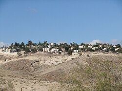
Kfar Adumim (Hebrew: כְּפַר אֲדֻמִּים. lit. Red Village) is a mixed religious-secular communal Israeli settlement in the West Bank. Located in the Judean Desert, it falls under the jurisdiction of Mateh Binyamin Regional Council. In 2015 it had a population of 4,145. Khan al-Ahmar, a Bedouin encampment, is located between Kfar Adumim and Ma'ale Adumim. The international community considers Israeli settlements in the West Bank illegal under international law, but the Israeli government disputes this. According to the Palestinian NGO Applied Research Institute-Jerusalem, Kfar Adumim is located on land confiscated from the town of 'Anata.
Contents
- Scene of stabbing at the kfar adumim junction reuters
- Map of Kfar Adumim
- History
- Education
- Notable residents
- References
Map of Kfar Adumim
History
Kfar Adumim was established in September 1979. Kfar Adumim was a settlement linked by a road secretly built by settlers in 1995. The road joins Anatot to Kfar Adumim, Nofei Prat, and Alon. According to Pinhas Wallerstein, then head of the Mateh Binyamin Regional Council, the road was one of a number of secretly built roads under construction in the area. Wallerstein claimed that as council head, he did not need permission to construct roads, but that he would stop construction if the Israel Defense Forces told him to.
Education
Kfar Adumim is home to the Ein Prat pre-military mechina.