
Population 5,299 (2011 census) Postal code 4879 | Postcode(s) 4879 | |
 | ||
LGA(s) Cairns Regional Council | ||
For rent 2 torbay street kewarra beach cairns qld australia
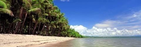
Kewarra Beach is a coastal suburb of Cairns, Queensland, Australia. It is bordered by the Coral Sea to the east and Kuranda National Park to the west. At the 2011 Australian Census the suburb recorded a population of 5,299.
Contents
- For rent 2 torbay street kewarra beach cairns qld australia
- Map of Kewarra Beach QLD 4879 Australia
- Kewarra beach resort and spa australia kewarra beach
- Facilities
- Transport
- History
- References
Map of Kewarra Beach QLD 4879, Australia
Kewarra beach resort and spa australia kewarra beach
Facilities
A small shopping centre is located on Poolwood Road. The foreshore reserve, Pelican Park, adjoins the beach. It has a swimming enclosure that excludes marine stingers at the north end. Other reserves include Brolga Park and Crocodile Park. Trinity Anglican School, which opened in 1983, has a campus for years Prep to 7. Tourist-oriented developments include Kewarra Beach Resort and Paradise Palms Country Club and Resort.
Transport
Kewarra Beach is 20 kilometres (12 mi) north of Cairns via the Captain Cook Highway. Sunbus runs a bus service between Cairns City Mall and Palm Cove that includes Kewarra Beach on its route.
History
The area was primarily utilised for growing sugar cane until the suburb was developed in the 1980s and 90s.The western side of the highway was developed with a golf course (Paradise Palms) with housing to the north and south.