
Opening date 1899 Length 120 m (394 ft) Creates Barnes Lake | Demolition date November 6, 1977 Width (base) 6.1 m (20.0 ft) Height 12 m | |
 | ||
Similar | ||
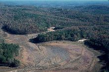
Kelly Barnes Dam was an earthen embankment dam once located in Stephens County, Georgia, just outside the city of Toccoa. It collapsed on November 6, 1977 after a period of heavy rainfall, and the resulting flood killed 39 people and caused $2.8 million in damages. The dam was never rebuilt, and the Toccoa Falls downstream of the dam site is now a memorial and tourist attraction on the campus of Toccoa Falls College.
Contents
- Map of Kelly Barnes Dam Georgia 30577 USA
- HistoryEdit
- Dam characteristicsEdit
- Dam failureEdit
- References
Map of Kelly Barnes Dam, Georgia 30577, USA
HistoryEdit
In 1899, the original rock crib dam was completed by Mr. E. P. Simpson in order to create a reservoir for a small hydroelectric power plant which began operating that same year. The plant, now a historical site on the Toccoa Falls College campus and called The Old Toccoa Falls Power Plant produced 200 KW (0.2 MW) for the town of Toccoa, Georgia. After receiving the power plant in 1933, the Toccoa Falls Institute wanted to develop a more stable electric power source and built an earthen embankment dam over the original rock crib dam between 1939 and 1940. After the Second World War, the dam was again raised. Barnes Lake, a 40-acre (16 ha) reservoir was created by the dam. The modifications provided power for Toccoa Falls Institute until 1957, when the power production was stopped, and the lake was only used for recreational purposes.
Dam characteristicsEdit
The dam was modified several times, and before the flood, the final dam was 38 feet (12 m) high, 400 feet (120 m) long and 20 feet (6.1 m) wide at its crest. The dam had two uncontrolled earthen spillways. The main spillway was 380 feet (120 m) long, 60–11 feet (18.3–3.4 m) wide and located on the left side of the structure. A low point on the right side and away from the dam could also be used as a secondary spillway in case the reservoir levels became too high.
The embankment dam was located about 2,000 feet (610 m) upstream from the Toccoa Falls and mostly consisted of residual soils and silt. The dam sat on a foundation of silt and stable biotite gneiss (rock).
Within the dam embankment were two masonry structures that helped support a pipe that was used as a low-level spillway and in the other, a penstock (pipe) for the hydroelectricity power plant. Neither were being used at the time of the flood.
Dam failureEdit
On November 6, 1977, at 1:30 am, the Kelly Barnes Dam failed after a period of heavy rain; seven inches had fallen from November 2–5. In particular, 3½ inches fell between 6 pm and midnight, November 5. A total of 200 feet (61 m) of the dam had failed, causing a peak of 24,000 cubic feet per second (680 m3/s) maximum discharge to burst downstream. Barnes Lake at the time held an estimated 27,442,800 cubic feet (777,090 m3) of water compared to a normal volume of 17,859,600 cubic feet (505,730 m3).
The flood caused 39 fatalities along with destroying nine houses, 18 house trailers, two college buildings and many motor vehicles. Five houses and five college buildings were also damaged. Two bridges on Toccoa Falls Drive and a culvert at County Farm Road were completely destroyed. The embankments at Georgia Highway 17 were destroyed on either side of the bridge, and one of the bridge abutments at Highview Road was destroyed. The water-supply pipe for the city of Toccoa was damaged and the city's water supply was contaminated for several days.
After the flood, Georgia's Governor George Busbee called for an immediate investigation, which was carried out by a Federal Investigative Board of the United States Geological Survey. Their report was released December 21, 1977, with no specific cause(s) cited for the failure. The investigators had no engineering plans for the dam and records of construction on the dam were based on witnesses, pictures and newspaper articles.
The investigation did, however, cite several possible or probable causes. The failure of the dam's slope may have contributed to weakness in the structure, particularly in the heavy rain. A collapse of the low-level spillway could have also exacerbated this problem. A 1973 photo showed a 12-foot-high (3.7 m), 30-foot-wide (9.1 m) slide had occurred on the downstream face of the dam, which may have also contributed or foreshadowed the dam failure. Overall, the dam itself was in poor condition and lacked a sufficient design.