
Established 1967 Province Nova Scotia | Nearest city Halifax Visitors 36,090 (in 2015-16) Area 404 km² | |
 | ||
Address 3005 Kejimkujik Main Parkway, Maitland Bridge, NS B0T 1B0, Canada Similar Georgian Bay Islands National, Bay of Fundy, Nahanni National Park Res, Bruce Peninsula National, Wood Buffalo National Profiles | ||
Kejimkujik national park history in stone nova scotia canada
Kejimkujik National Park (often called Keji for short) is part of the Canadian National Parks system, located in the province of Nova Scotia. The park consists of two separate properties: the main park is located in the upland interior of the Nova Scotia peninsula bordering Queens and Annapolis counties; and the smaller Kejimkujik Seaside unit, located on the Atlantic coast of Queens County. The park covers 404 km2 (156 sq mi). The inland unit is designated a National Historic Site of Canada, making Kejimkujik unique in the park system as the only national park whose virtually entire area is a National Historic Site.
Contents
- Kejimkujik national park history in stone nova scotia canada
- Kejimkujik national park a drive through
- Geology and SoilsEdit
- Landscape and EnvironmentEdit
- Methyl mercury contaminationEdit
- RiversEdit
- LakesEdit
- Interior CampingEdit
- HikingEdit
- WildlifeEdit
- Dark Sky PreserveEdit
- The Tent DwellersEdit
- Kejimkujik SeasideEdit
- ClimateEdit
- References
Kejimkujik national park a drive through
Geology and SoilsEdit
The bedrock of the park consists of Precambrian to Ordovician period quartzite and slate, plus Devonian period granite. All of these rocks, especially quartzite, have a high silica content and provide scanty amounts of nutrients to the soils that develop on them. The slate, however, is fine-grained and produces a loamy soil which yields its nutrients more quickly than the stony sandy loams and loamy sands found over the coarse-grained rocks. Most of the slaty loams occur around Kejimkujik Lake. Deep outwash sands and gravels form a band west of the lake. Elsewhere the soil landscape is dominated by the cobbly, often shallow granite or quartzite material. Podzols underlie most well-drained areas. Gleysols and peat bogs dominate where drainage is poor. The park receives acid rain, and its soils have few available acid-buffering minerals, so strong acidity is the rule for soils and waters—even large bodies of water such as Kejimkujik Lake.
Landscape and EnvironmentEdit
Kejimkujik National Park conserves two distinct environments:
The large main section of the park is a forested upland plain located approximately 50 kilometres inland from the South Shore and Annapolis Valley and may be accessed from Trunk 8 running between Liverpool and Annapolis Royal.
The smaller Kejimkujik Seaside includes white sandy beaches and coastal wetland areas. The park includes habitat for the endangered piping plover and other coastal birds. It is located off Highway 103 near the villages of Port Mouton and Port Joli.
The park is named after Kejimikujik Lake, the largest lake inside the main section of the park. The many lakes and rivers form interior waterways that were important canoe routes between the Bay of Fundy and the Atlantic for the ancestors of the Mi'kmaq First Nations. The park also contains the petroglyphs left behind by these inhabitants. The lake's Mi'kmaq name has been translated as "attempting to escape" or "swollen waters", possibly related to fishing weirs placed on the lake. The park's official stance is that Kejimkujik is a Mi'kmaq word meaning "tired muscles".
Methyl mercury contaminationEdit
in 1995, Environment Canada scientists discovered that the concentration of methyl mercury in the park's loons was highly elevated, spurring investigation as to where it originated. After 20 years of research, the source is still unclear.
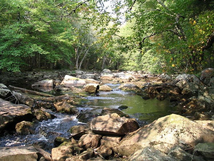
RiversEdit
Rivers in the park include the:
LakesEdit
In addition to the largest and namesake lake, Kejimikujik Lake, major lakes in the park include:
Interior CampingEdit
Although there are numerous drive-in campgrounds in Keji the park is also known for its interior camping: campsites which are only accessible by canoe or hiking in the summer, or ski or snowshoe in the winter. Keji provides excellent canoeing, with numerous navigable lakes and rivers forming an interconnected system. The further a camper progresses from access points, the more wild the park becomes, and it is possible to spend several days in the interior with little or no sight of other campers. Park staff maintain portages along major routes.
Interior campsites can vary widely, and none has any permanent shelter. Sufficient bad-weather gear (tents, tarps, etc.) should be brought so the trip can remain enjoyable in the face of less-than-perfect weather. All campsites have a firebox, which should be the only location used for fires. Fires made in non-prepared sites can cause underground roots to burn, allowing the fire to spread.
HikingEdit
There are 15 hiking trails available for both day hikes and overnight backpack camping, the longest being the 56 km Liberty Lake trail. Resource issues have led the park to close some hiking trails in recent years such as the former Luxton Lake Trail.
WildlifeEdit
Interior camping can provide excellent wildlife viewing opportunities. Moose, warblers, white-tailed deer, barred owls, beavers, porcupines, woodpeckers, martens, and loons are not uncommon, especially along waterways. Black bears, though present in the park, are seldom seen. Coyotes are also present in this park. Harbour and grey seals are often seen along the seaside coast basking on its rocks. There are several uncommon species of organisms that call Kejimkujik their home. The Blanding's turtle which is considered an endangered species in Nova Scotia is similar in size to the common painted turtle; however the Blanding's is characterized by its yellow neck. Juveniles measure between 5 and 12 cm in carapace diameter while adult females can measure between 25 and 35 cm. It is a very gentle turtle that frequently nests on beaches that are accessible by the public. For this reason it is important for visitors to be careful not to disturb nesting turtles, and to report any sightings to the visitor centre. The eastern ribbon snake is a threatened species in Nova Scotia and lives in several isolated areas in the park. The eastern ribbon snake, upon first glance, may be easily confused with the common garter snake, but the eastern ribbon snake is defined by three longitudinal yellow stripes on the dorsal side and a black or dark brown colouration. Adult eastern ribbon snakes in the park usually measure between 50 and 70 cm in length. Kejimkujik is one of two places in Canada where Hydrocotyle umbellata or water pennywort exists. The other is in Yarmouth County.
Dark Sky PreserveEdit
The park was designated as a Dark Sky Preserve on July 6, 2010 by the Royal Astronomical Society of Canada as part of their Dark Sky Preserve Program. The designation recognizes the commitment by the park to protect the nighttime environment from the effects of artificial lighting. This policy will maintain the pristine quality of most of the park by limiting the use of artificial lighting and will benefit the nocturnal wildlife scotobiology within the park and preserve the appearance of the night sky for stargazers.
The Tent DwellersEdit
The Tent Dwellers is a book by Albert Bigelow Paine which chronicles his travels through inland Nova Scotia on a trout fishing trip with Dr. Edward "Eddie" Breck, and with guides Charles "the strong" and Del "the stout", in the early 1900s. Originally published in 1908, the book takes place in what is now Kejimkujik National Park and the Kejimkujik Seaside Tobeatic Game Reserve. The descriptions of the park contained in the book are beautifully written and uncannily accurate:
... the shores are green; the river or brook is clear and cold – and tarry black in the deep places; the water leaps and dashes in whirlpools and torrents, and the lakes are fairy lakes, full of green islands – mere ledges, many of them, with two or three sentinel pines – and everywhere the same clear, black water, and always the trout, the wonderful, wild, abounding Nova Scotia trout.
Sadly, the trout which brought Paine and Breck to the park area are now largely absent, due to higher acid levels in the water from acid rain.
Kejimkujik SeasideEdit
In 1985 Parks Canada acquired lands along the coast of Nova Scotia about 25 kilometers (16 mi) south of Liverpool. In 1988 these lands became part of Kejimkujik National Park to include coastal ecosystems within Kejimkujik National Park. The land acquisition was important for Canadian culture and heritage due to the expanding development along the East Coast of Canada. These properties are still the largest tract of undeveloped coast in Nova Scotia.
Kejimkujik Seaside includes two sides, one of which contain trails and parking facilities at St Catherines River Beach. The Little Port Joli Basin and Basin Lake side is accessible but not marked as a national park with signage. The two barrier beaches are both nesting sites for the endangered piping plover. The lagoons are important migration stops for many species of birds such as short-billed dowichers, semipalmated plovers, sandpipers and black-bellied plovers.
The Little Port Joli Basin and Basin Lake are being used for European green crab research. The removal of the green crabs are essential in research into the dwindling fish stocks on the East Coast.
Two trails exists at Kejimkujik Seaside. Port Joli Head Trail is a coastal trail that takes you along the rocky coast of Port Joli Head around berms, and ponds. Cormorants, deer, and the occasional black bear can be seen on this trail. Harbour Rocks Trail takes you straight to the beach through the upland barrens and bogs. The trail continues along the rocky shore to St Catherines River Beach where the clean white sand beach well greet you with its turquoise waters. Seals, cormorants, jellyfish, plovers, great blue heron, deer, mink, osprey and many other forms of wildlife are often seen in this area.
ClimateEdit
The park has a humid continental climate (Köppen climate classification Dfb) with four distinct seasons. Being located inland, in the western part of Nova Scotia, the park has warmer temperatures and higher precipitation than eastern sections of Nova Scotia. Winters are cold with a January average of −6.1 °C (21.0 °F). During this time of the year, the maximum temperature often stays below freezing although frequent mild spells push maximum temperatures above freezing frequently (about 12–19 days from December to February) and occasionally above 10 °C (50.0 °F) when the wind is from the southwest. On average, there are 8 days where the temperature falls below −20 °C (−4.0 °F). Winters are characterized by stretches of unsettled weather, resulting in high precipitation and cloud cover. Snowfall is high, averaging 244 centimetres (96.1 in) a year.
Summers are warm with a July average of 18.4 °C (65.1 °F) and precipitation is lower (though significant) than the winter months. Temperatures in the park rarely exceed 30 °C (86.0 °F), occurring on 2 days per year owing to the moderating influence of the ocean. Spring and fall are transitional seasons that feature mild temperature although they are unpredictable. The park receives 1,399 millimetres (55 in) of precipitation per year, which is fairly evenly distributed throughout the year.