
Country United States County Buffalo Area code(s) 308 Population 32,174 (2013) | Time zone Central (CST) (UTC-6) Elevation 656 m Local time Saturday 8:17 AM | |
 | ||
ZIP codes 68845, 68847, 68848 (P.O. Box), 68849 UNK Weather -5°C, Wind E at 11 km/h, 66% Humidity University | ||
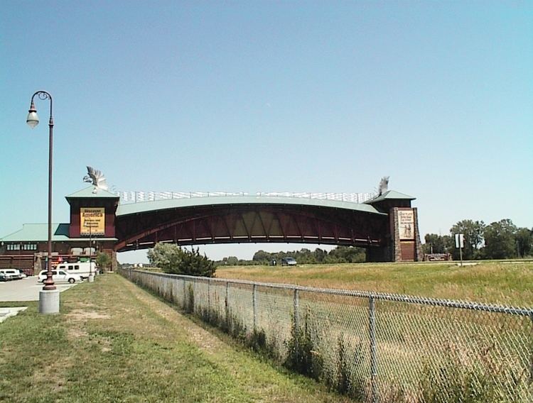
The archway museum kearney nebraska
Kearney /ˈkɑːrni/ is a city in and the county seat of Buffalo County, Nebraska, United States. The population was 30,787 at the 2010 census. It is home to the University of Nebraska at Kearney. The westward push of the railroad as the Civil War ended gave birth to the community.
Contents
- The archway museum kearney nebraska
- Map of Kearney NE USA
- Nathan moore gibbon kearney nebraska ice storm january 16th 2017
- Geography
- Demographics
- 2010 census
- 2000 census
- History
- Government
- Education
- University
- Economy
- Top employers
- Attractions
- Local media
- Outdoor areas
- In popular culture
- References
Map of Kearney, NE, USA
Nathan moore gibbon kearney nebraska ice storm january 16th 2017
Geography
Kearney is located at 40°42′3″N 99°4′52″W (40.700731, -99.081150). Strategically located on I-80 with convenient access to major markets like Omaha-Lincoln, Denver, Kansas City, Des Moines, Wichita and Cheyenne, Kearney is at the center of a 7-state region and 20 million people. According to the United States Census Bureau, the city has a total area of 13.00 square miles (33.67 km2), of which, 12.77 square miles (33.07 km2) is land and 0.23 square miles (0.60 km2) is water.
Demographics
Kearney is the principal city of the Kearney, Nebraska Micropolitan Statistical Area, which consists of Buffalo and Kearney counties.
2010 census
As of the census of 2010, there were 30,787 people, 12,201 households, and 7,015 families residing in the city. The population density was 2,410.9 inhabitants per square mile (930.9/km2). There were 12,738 housing units at an average density of 997.5 per square mile (385.1/km2). The racial makeup of the city was 92.3% White, 1.0% African American, 0.3% Native American, 1.8% Asian, 3.1% from other races, and 1.4% from two or more races. Hispanic or Latino of any race were 7.3% of the population.
There were 12,201 households of which 29.4% had children under the age of 18 living with them, 43.7% were married couples living together, 9.9% had a female householder with no husband present, 4.0% had a male householder with no wife present, and 42.5% were non-families. 30.4% of all households were made up of individuals and 9% had someone living alone who was 65 years of age or older. The average household size was 2.36 and the average family size was 2.96.
The median age in the city was 29 years. 22.2% of residents were under the age of 18; 20.5% were between the ages of 18 and 24; 25.6% were from 25 to 44; 20.6% were from 45 to 64; and 11.1% were 65 years of age or older. The gender makeup of the city was 48.9% male and 51.1% female.
2000 census
As of the census of 2000, there were 29,952 people, 10,549 households, and 6,160 families residing in the city. The population density was 2,498.5 people per square mile (964.6/km2). There were 11,099 housing units at an average density of 1,010.9 per square mile (390.3/km2). The racial makeup of the city was 95.18% White, 0.63% African American, 0.38% Native American, 0.92% Asian, 0.04% Pacific Islander, 1.68% from other races, and 1.17% from two or more races. Hispanic or Latino of any race were 4.08% of the population.
There were 10,549 households out of which 30.3% had children under the age of 18 living with them, 45.7% were married couples living together, 9.7% had a female householder with no husband present, and 41.6% were non-families. 28.7% of all households were made up of individuals and 9.5% had someone living alone who was 65 years of age or older. The average household size was 2.37 and the average family size was 2.96.
In the city, the population was spread out with 22.2% under the age of 18, 23.9% from 18 to 24, 26.2% from 25 to 44, 17.1% from 45 to 64, and 10.6% who were 65 years of age or older. The median age was 27 years. For every 100 females there were 92.6 males. For every 100 females age 18 and over, there were 89.7 males.
The median income for a household in the city was $34,829, and the median income for a family was $46,650. Males had a median income of $30,150 versus $22,366 for females. The per capita income for the city was $17,713. About 7.4% of families and 13.4% of the population were below the poverty line, including 11.8% of those under age 18 and 8.9% of those age 65 or over.
History
The original settlement in the area was called Dobytown, located 2 miles (3.2 km) southeast of the present-day Kearney. Later the city was moved and renamed after the nearby Fort Kearny (with an extra "e" added, but pronounced the same), a United States Army outpost along the Oregon Trail in the middle of the 19th century. The fort was named after Colonel (later General) Stephen W. Kearny. The "e" was added by mistake sometime afterwards by postmen who consistently misspelled the town name; eventually it just stuck. The current location of the city is on the north side of the Platte River and steadily grew as a result of the influence of the railroad.
In 1912, a Catholic Diocese was centered here. This status was removed in 1917, with the creation of other dioceses. In 1997, the city began to be used as a titular see by the Catholic Church.
Government
The council-manager form is used in Kearney. The City Council makes legislative and policy-making decisions. There are five members elected city-wide to serve four-year terms which are staggered. The council manager form of government was adopted in 1950. Michael W. Morgan currently serves as city manager.
The council appoints a city manager to implement policies, prepare a budget, appoints department heads, and recommends areas that the council needs to attend. There are five members elected city-wide serving staggered four-year terms. One member of the City Council is chosen by the council to be Mayor. Stanley Clouse is the Mayor.
Gov. Dave Heineman has announced that Kearney is one of two cities that has been selected to participate in a new initiative designed to develop a new technology/data center park in Nebraska.
Education
University
University of Nebraska at Kearney (UNK) is located in the city. The campus is a 235-acre (0.95 km2) residential campus with more than 37 buildings. It was founded in 1905 as Nebraska State Normal School at Kearney and became Nebraska State Teachers College in 1921. Between 1963 and 1991 the school was known as Kearney State College. The college's name was changed to University of Nebraska at Kearney in 1991 when it joined the University of Nebraska system.
Economy
Companies headquartered in Kearney include Citizens Telecommunications Company of Nebraska and Buckle.
Top employers
According to Buffalo County Economic Development, the top non-manufacturing employers in the city are:
The top manufacturing employers are:
Attractions
Kearney is home to several museums, many of which reflect its location on the California, Mormon, Oregon, and Pony Express trails, and the Lincoln Highway.