
Elevation 453 m (1,486 ft) | ||
 | ||
Time zone Sri Lanka Standard Time (UTC+5:30) | ||
Katugastota (Sinhala: කටුගස්තොට, Tamil: கடுகஸ்தொட) is a suburb of the city of Kandy in Kandy District, Central Province of Sri Lanka. It is located along the Kandy-Jaffna A9 highway approximately 4 km (2.5 mi) from the centre of Kandy. The suburb has shown rapid development in the past years with major upgrades to the road network and pavements, along with the completion of the new Katugastota Bridge in 2009.
Contents
Map of Katugastota, Sri Lanka
Etymology
The Sinhalese name කටු-ගස්-තොට Katu-gas-tota implies about a port with thorn trees. Another belief is that the name is derived from the Sinhalese name කඩු-ගත්-තොට which means "port with sword-bearers".
History
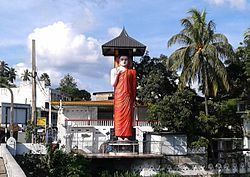
According to the histories, Sri Lanka has been divided into three parts well known as Ruhunu, Maya and Pihiti, with each of them divided into kingdoms, provinces and districts as per the 'Tun-Sinhale proposal' and Katugastota was the center point of Sri Lanka. The 'Three Sinhala Seemaramaya', together with the '18 Riyan statue of Lord Buddha' still remain to show the division point.
Hospitals
Katugastota has two hospitals, the Katugastota Hospital and the Kandy Private Hospital (KPH). KPH is located approximately 2.5 km (1.6 mi) from the Katugastota towards the Kandy city centre. It provides both out patient, specialist channeling services and residential treatment facilities.
Government banks
The Peoples Bank is located in the Kandy-Kurunegala high way. The Bank of Ceylon Katugastota branch is located in the Madawala Road. The Sampath Bank, Commercial Bank, Seylan Bank and DFCC bank are the private banks in Katugastota. The Sampath bank is located in Madawala road approximately 100 m from the Bank of Ceylon bank. The DFCC Bank is located right before the DFCC bank and the Seylan bank is located in Kandy-Kurunegala highway approximately 200 m from the Katugastota Bridge before St. Anthony’s Girls College.
Schools
The most well known school in Katugastota is St. Anthony's College
Climate
Situated in the Central Province, Sri Lanka, Katugastota generally enjoys a cooler and comfortable climate.