
 | ||
Similar Uluru, Kings Canyon, Kakadu National Park, Mount Conner, Nitmiluk National Park | ||
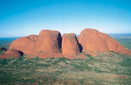
Kata Tjuta, Pitjantjatjara: (Kata Tjuṯa), also known as the Olgas, is a group of large, domed rock formations or bornhardts located about 365 km (227 mi) southwest of Alice Springs, in the southern part of the Northern Territory, central Australia. Uluru, also known as Ayers Rock, located 25 km (16 mi) to the east, and Kata Tjuta/Mount Olga form the two major landmarks within the Uluru-Kata Tjuta National Park. The park is considered sacred to the Aboriginal people of Australia.
Contents
- Map of Kata Tjuta 2F Mount Olga Petermann NT 0872 Australia
- The red center of australia uluru kata tjuta in hd
- Name
- Geologic origin
- Legends
- Transportation
- References
Map of Kata Tjuta %2F Mount Olga, Petermann NT 0872, Australia
The 36 domes that make up Kata Tjuta/Mount Olga cover an area of 21.68 km2 (8.37 sq mi), are composed of conglomerate, a sedimentary rock consisting of cobbles and boulders of varying rock types including granite and basalt, cemented by a matrix of sandstone. The highest dome, Mount Olga, is 1,066 m (3,497 ft) above sea level, or approximately 546 m (1,791 ft) above the surrounding plain (198 m (650 ft) higher than Uluru). Kata Tjuta is located at the eastern end of the Docker River Road.
The red center of australia uluru kata tjuta in hd
Name
The alternative name, The Olgas, comes from the tallest peak, Mount Olga. At the behest of Baron Ferdinand von Mueller, Mount Olga was named in 1872 by Ernest Giles, in honour of Queen Olga of Württemberg (born Grand Duchess Olga of Russia, daughter of Tsar Nicholas I). She and her husband, King Charles I of Württemberg, had marked their 25th wedding anniversary the previous year by, amongst other things, naming Mueller a Freiherr (baron), making him Ferdinand von Mueller; that was his way of repaying the compliment.
On 15 December 1993, a dual naming policy was adopted that allowed official names consisting of both the traditional Aboriginal name and the English name. As a result, Mount Olga was renamed Mount Olga / Kata Tjuta. On 6 November 2002, following a request from the regional Tourism Association, the order of the dual names was officially reversed, to Kata Tjuta / Mount Olga.
Geologic origin
The region surrounding Kata Tjuta / Mount Olga lies in the Amadeus Basin, an intracratonic basin formed during the Adelaidian, roughly 850-800 million years ago. During the Petermann Orogeny, approximately 550 million years ago, an event known as the Woodroffe Thrust lifted granulite facies rocks northward over low-grade metamorphic rocks. The eventual erosion of the formation resulted in a molasse facies, or deposition in front of rising mountains, in this case the Petermann Orogeny, to create the deposit known as the Mount Currie Conglomerate. The Mount Currie Conglomerate is made predominately of basalt, porphyry, granite, gneiss and volcanic rock fragments with a matrix composed of angular quartz, microcline and orthoclase among other minerals.
Both Uluru / Ayers Rock and the Kata Tjuta / Mount Olga are made of sediment originating in this Mount Currie Conglomerate and both have a chemical composition similar to granite. Scientists using Rb/Sr dating techniques to accurately date the rock have given it an age of 600 million years ago, matching the date of the Woodroffe Thrust event. The actual fresh rock that makes up the Kata Tjuta / Mount Olga and Uluru / Ayers Rock is medium to dark gray with green or pink hues in some laminae. The bright orange-red hue, for which the structures are noted, is due to a patina over finely divided feldspar coated in iron oxide.
Legends
There are many Pitjantjatjara Dreamtime legends associated with this place and indeed everything in the vicinity including Uluru / Ayers Rock. A number of legends surround the great snake king Wanambi, who is said to live on the summit of Kata Tjuta / Mount Olga and only comes down during the dry season. The majority of mythology surrounding the site is not disclosed to outsiders, and in particular, women. As is the custom, should women become known to the "men's business" they are susceptible to violent attacks, even death. The Anangu Aborigines believe the great rocks of Kata Tjuta are homes to spirit energy from the 'Dreaming', and since 1995 the site is being used once again for religious ceremonies.
Transportation
Kata Tjuta / Mount Olga can be accessed via Ayers Rock Airport. It is then a 55 km drive south, then west. Visitors are required to pay a National Park [2] entry fee, which is currently A$25 per person. Visitors can also drive along the Lasseter Highway which joins the Stuart Highway 200 km south of Alice Springs at the township of Erldunda. The drive is 4½ hours from Alice Springs.