
Prominence 70 m (230 ft) Elevation 1,350 m | Range Vosges | |
 | ||
Similar | ||
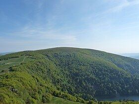
The Kastelberg is the fourth highest summit of the Vosges Mountains. It is located on the border between the French regions of Alsace and Lorraine.
Contents
Map of Kastelberg, 68380 Metzeral, France
EtymologyEdit
In German Kastelberg means mountain of the castle.
GeographyEdit
The mountain is divided between the French municipalities of La Bresse (dep. of Vosges, Lorraine) and Metzeral (dep. of Haut-Rhin, Alsace). Nearby the mountain, on its Lorraine side, there is the ski resort of La Bresse, which offers an area served by skilifts ranging from 650 metres to 1350 metres as well as 50 km of cross country ski trails.
A locality of the Kastelberg named Wormsawald-Ammelthal (literally swallow's nest) harbours the most sturdy snowfield of the Vosges, which usually lasts up to July or, remarkably, to August.)
References
Kastelberg Wikipedia(Text) CC BY-SA