
Prominence 330 m | Elevation 1,982 m | |
 | ||
Similar | ||
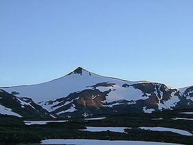
Karitinden is a mountain in the Tafjordfjella mountain range inside Reinheimen National Park on the border of Møre og Romsdal and Oppland counties in Norway. The top of the mountain is a tripoint border junction for Skjåk Municipality (in Oppland county), and Norddal Municipality and Rauma Municipality (in Møre og Romsdal county). The nearest village is Tafjord which lies 17 kilometres (11 mi) to the northwest. The lake Tordsvatnet lies 4 kilometres (2.5 mi) southeast of the mountain and the mountain Puttegga lies 4 kilometres (2.5 mi) to the northwest.
Contents
Map of Karitinden, 2693 Nordberg, Norway
Name
The first element is the female name Kari and the last element is the finite form of tind which means "mountain peak". The reason for the name, and who the person Kari was, is unknown.
References
Karitinden Wikipedia(Text) CC BY-SA