
Arabic كرتيا Palestine grid 124/116 Local time Friday 11:09 AM | Area 13,709 dunams13.7 km² Date of depopulation 18 July 1948 | |
 | ||
Name meaning "Thick, tangled grass" (possibly) Also spelled Karatayya, Karatiya, Qaratiyya Weather 19°C, Wind N at 14 km/h, 67% Humidity | ||
Khalid al khaldi on fleeing karatiyya
Karatiyya (Arabic: كرتيا) was a Palestinian Arab village of 1,370, located 29 kilometers (18 mi) northeast of Gaza, situated in a flat area with an elevation of 100 meters (330 ft) along the coastal plain of Palestine and crossed by Wadi al-Mufrid.
Contents
- Khalid al khaldi on fleeing karatiyya
- History
- Ottoman era
- British Mandate era
- 1948 War and aftermath
- References
History
Byzantine ceramics have been found here.
In the 12th century, a castle called Galatie was built on the village site by the Crusaders, it was subsequently captured by the Ayyubids under Saladin in 1187, and destroyed September 1191.
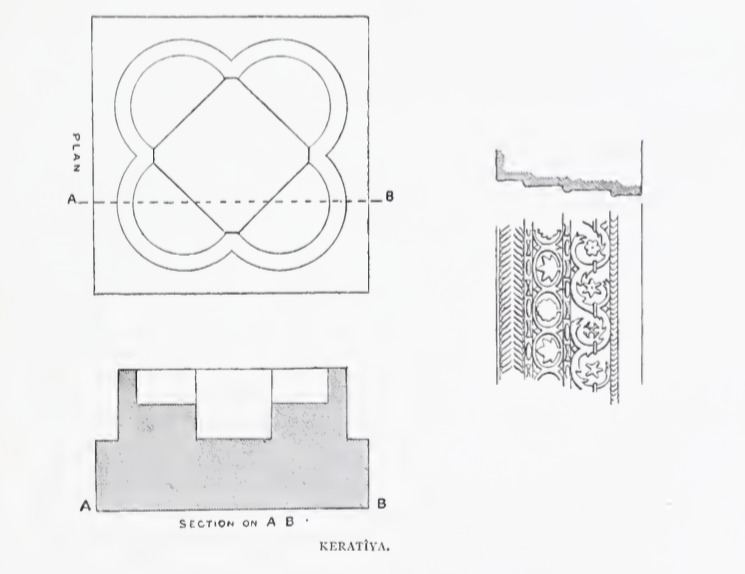
The place called Kulat el Fenish by the village was apparently once a church. The remains were seen in 1875: "The tower on the mound is called Kulat el Fenish. It is a solid block of masonry, standing some 20 or 30 feet in height. Near it lie shafts and bases of white marble, and an elaborate cornice, well and deeply cut. There is also a font, like that at Beit 'Auwa (Sheet XXI.), formed by four intersecting circles, and measuring 37 feet along the diameter, and 2 feet high."
In 1226, Arab geographer Yaqut al-Hamawi writes of the village under Ayyubid rule as "Karatayya" as "a town near Bait Jibrin, in the Province of Filastin. It belongs to Jerusalem."
The Mamluk sultan al-Nasir ibn Qalawun camped in Karatayya in 1299 on his way to fight the Mongols. 14th-century Arab geographer Al-Dimashqi reports that at times it was a part of Mamlakat Ghazzah ("Kingdom of Gaza").
Ottoman era
Karatiyya was incorporated into the Ottoman Empire in 1517 with the rest of Palestine, and by 1596 it was under the administration of the nahiya of Gaza, part of Sanjak of Gaza. A population of 253, it paid taxes on wheat, barley, fruit, vineyards, beehives, and goats.
In 1863 Victor Guérin found it to be a small village with many houses demolished. To the north of this hamlet, on a nearby hill, were huge sections of walls and the remains of a square tower, three quarters destroyed, called "El-Kala'", or "the Castle". South of the village was a oually, decorated with two ancient grey-white marble columns. An Ottoman village list of about 1870 indicated 73 houses and a population of 196, though the population count included only men.
In the 19th century, a ruined tower stood atop a mound just outside the village which was built in an open plain.
British Mandate era
During the British Mandate of Palestine period in the 20th century, the village houses were built of adobe brick and it relied on the nearby town of al-Faluja for medical, commercial, and administrative services. Karatiyya itself, had a mosque, a grain mill, and an elementary school—the latter was built in 1922 and had an enrollment of 128 students in the mid-1940s. Domestic water was supplied by two wells dug within the village and the primary agricultural crops were grain and prickly pears.
In the 1922 census of Palestine, conducted by the British Mandate authorities, Karatiya had a population of 736 inhabitants, all Muslims, increasing in the 1931 census to 932, still all Muslims, in 229 houses.
In 1945 Karatiyya had a population of 1,370 Muslims, with a total of 13,709 dunams of land, according to an official land and population survey. Of this, 321 dunams were used for plantations and irrigable land, 12,928 for cereals, while 48 dunams were built-up land.
1948 War, and aftermath
As a part of a new policy the Haganah blew up a house in Karatiyya on the night of December 9, 1947, the orders to the Givati Brigade who executed the437 order had been for "two houses".
Karatiyya was captured by the Israeli Army's 89th Mechanized Battalion, commander Moshe Dayan, on July 18, 1948 as part of Operation Death to the Invader. Its inhabitants fled upon their arrival, according to Dayan. According to Benny Morris, the village "was harassed by machine-gun fire and abandoned by its inhabitants". Israeli forces intended to link their northern territory with that held by Israeli forces in the Negev, but succeeded only partially, only taking control of Hatta and Karatiyya. After it was stormed by Dayan's troops he controversially withdrew them leaving a Givati infantry company to hold the position. A fierce battle ensued between them and the Egyptian Army who got as far as the village outskirts. When two Egyptian tanks were on the verge of breaking the Israeli defenses from the south, a unit hiding behind a wall of prickly pear cacti, armed with anti-tank weapons "changed the course of the battle", according to Haganah accounts.
On August 20, 1948, Ben-Gurion together with Yehoshua Eshel, presented a plan for 32 new Jewish settlement on newly depopulated Palestinian villages, for Karatiyya one proposed a settlement named Otzem or Komemiyut
Three Israeli settlements were eventually founded on village land: Komemiyut in 1950 and Revaha in 1953, close to the village site. Nehora, established in 1956, is partly on village land, and partly on land belonging to al-Faluja.
The Palestinian historian Walid Khalidi described Karatiyya in 1992: "Piles of debris are scattered on the site, and a destroyed cemetery (partially hidden among eucalyptus trees) can be seen. An agricultural road runs through it. Grain and alfalfa are grown by Israeli farmers on the site and surrounding lands."