
Country New Zealand Local time Friday 8:30 PM | Region West Coast Population 423 (2006) | |
 | ||
Weather 19°C, Wind E at 13 km/h, 86% Humidity | ||
New zealand s best kept secret karamea
Karamea is a town on the West Coast of the South Island of New Zealand.
Contents
Map of Karamea, New Zealand
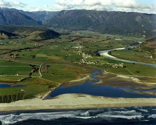
It is the northernmost settlement of any real size on the West Coast, and is located 96 kilometres (60 mi) north-east by road from Westport. There is no other connecting road to the town - the road north ends at the Kohaihai River some 20 kilometres (12 mi) from Karamea, at the south western end of the Heaphy Track. The Karamea River flows past the town to the south and into the Karamea Bight, part of the Tasman Sea.
The population was 423 in the 2006 Census, a decline of 18 from 2001.
The name Karamea is Maori - despite local jokes suggesting it was named by an Italian for his love - and is thought to either mean "red ochre" or be a corruption of Kakarataramea, "the smell of speargrass leaves". The large bay formed by the curve of coastline north for 100 kilometres (62 mi) from Cape Foulwind is called Karamea Bight.
The Oparara River runs through the area, and the Oparara Basin Arches, large natural river tunnels, are a well-known tourist destination, though tourism in the area is limited compared to most other parts of New Zealand. The Karamea River flows into the sea just south of the main township, and there is a large lagoon which completely clears of water at low tide, and completely fills with water at high tide.
Karamea township offers local services including a general store, supermarket, petrol pumps, information centre, cafe, hotel, camping ground, motels, backpackers and art & craft shop.
History
Maori occupation in this area seems to have been mainly seasonal. The first Europeans and Chinese would have been early gold-miners in the 1860s. The first true settlement of the area took place in 1874 when the (then) fine harbour and sea provided the only means of contact with the outside world. This original settlement was on the South Terrace but poor soil forced the inhabitants down to the river valley. One side of the river (Umere) was known as the Land of Promise, the other side (Arapito) as the Promised Land. Farming was to become a major industry, but timber, flax and gold also provided a means to a living. The Murchison earthquake in 1929 caused the silting up of the harbour and cut the community's road link for about two years. Dairying remains a major industry of Karamea. Sphagnum moss, possum control, fishing, fine furniture production, horticultural tomato growers and a plant nursery also provide income, while the service industry employs approximately a quarter of the workforce. Fruit grown in the area includes tamarillos, which can be grown here due to the area's mild and frost-free microclimate.
Tourism
Tourists visit Karamea all year round to enjoy the many scenic attractions in the region, which is enveloped by the Kahurangi National Park. One of New Zealand's nine "Great Walks," the Heaphy Track starts (or finishes) at the Kohaihai River, which is about 20 kilometres (12 mi) north of Karamea. The Wangapeka Track also begins (or ends) near Karamea. The Oparara Basin with the Oparara Arches, Honeycomb Caves and rainforest walks is also a popular attraction. Tourism is a fast-growing segment of the local economy, and the region is often said to be "New Zealand's best-kept secret".
Education
Karamea Area School is a coeducational composite school (years 1–15), with a decile rating of 5 and a roll of 93. The school celebrated 125 years of settlement and schooling in 2000.