
Current Representative Vacant Median income 40,917 | Population (2000) 672,101 Cook PVI R+14 | |
 | ||
Distribution 78.90% urban21.10% rural Ethnicity 83.6% White6.9% Black2.4% Asian6.6% Hispanic1.2% Native American0.7% other | ||
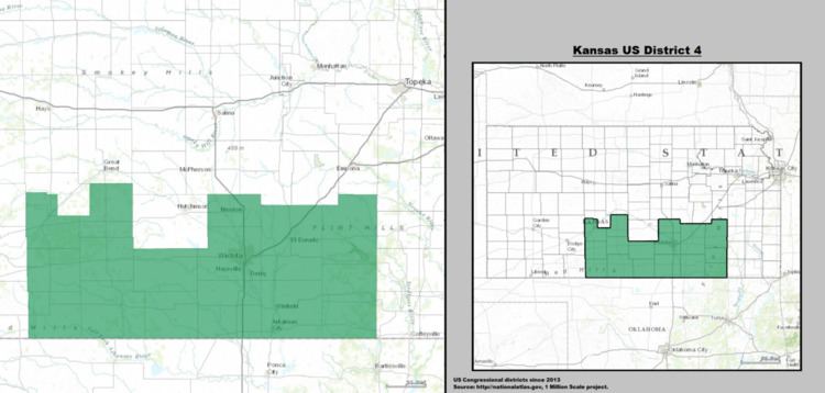
Kansas's 4th Congressional District is a Congressional District in the U.S. state of Kansas. Based in the south central part of the state, the district encompasses the city of Wichita and surrounding areas.
Contents
- Summary Political History
- Demographics
- List of representatives
- Historical district boundaries
- References
The district currently has no representative. It was represented by Republican Mike Pompeo, until he became the Director of the Central Intelligence Agency on January 23, 2017.
Summary Political History
The Kansas 4th Congressional District is historically a strongly Republican district, almost exclusively represented, over the last half century, by Republicans—with the sole exception of a popular moderate Democrat, Dan Glickman (who lost his bid for re-election to a 10th term in 1994).
Since the 1980s (and peaking with the 1991 Summer of Mercy protests), the District's major city, Wichita (where most 4th District voters reside), is often referred to in national media as the center, or "ground zero," of the nation's anti-abortion movement -- a primary factor that Glickman has credited for his defeat, -- and which has remained a major influence in 4th District politics, with both of Glickman's successors (Todd Tiahrt and Mike Pompeo) claiming strong anti-abortion views.
As of February, 2017, no other Democrat has won election to the Congressional seat lost by Glickman, which has since gone to conservative, anti-abortion Republicans, routinely, by a roughly two-to-one margin in subsequent races.
In the 2016 national elections, the District's Republican nominees for President (Trump) and Congressman (Pompeo) overwhelmingly defeated the Democratic nominees (Clinton and Giroux), by two-to-one margins in the 4th District. (as happened with Pompeo's previous Democratic challengers).
In 2012, a feud between conservative and moderate Republicans in the Kansas Legislature stymied progress on mandatory decennial redistricting (boundary changes to reflect new demographic data from the 10-year Census). With elections approaching, the federal courts intervened and drew the district boundaries, shifting the Fourth District westward, into more conservative territory.
Demographics
Most of the approximately 670,000 citizens of the Fourth District reside in the state's largest city, Wichita (approximate population 390,000), or the surrounding Sedgwick County (approximate population 511,000). Nearly all live within the Wichita MSA (approximate population 650,000). The rest live in small towns and rural areas in adjacent counties, and counties farther west and east.
Following redistricting after the 2000 U.S. Census, there were 672,101 people, 261,106 households, and 177,358 families residing in the district. The population density was 70.5/mi² over a land area of 9,531 square miles (24,690 km2). There were 285,830 housing units at an average density of 30.0/mi². The racial makeup of the district is 83.56% White, 6.86% Black or African American, 2.44% Asian, 1.23% Native American, 0.05% Pacific Islander, 3.28% from other races, and 2.59% from two or more races. Hispanic or Latino of any race were 6.57% of the population.
There were 261,106 households out of which 36.53% had children under the age of 18 living with them, 53.87% were married couples living together, 10.14% had a female householder with no husband present, and 32.07% were non-families. 27.62% of all households were made up of individuals and 9.99% had someone living alone who was 65 years of age or older. The average household size was 2.52 and the average family size was 3.10.
In the district the population distribution by age is 27.69% under the age of 18, 9.13% from 18 to 24, 28.98% from 25 to 44, 21.19% from 45 to 64, and 13.00% who were 65 years of age or older. The median age was 35.0 years. For every 100 females there were 97.32 males. For every 100 females age 18 and over, there were 94.67 males.
The median income for a household in the district is $40,917, and the median income for a family was $49,650. Males had a median income of $36,701 versus $25,237 for females. The per capita income for the district was $20,041. About 7.0% of families and 9.6% of the population were below the poverty line, including 12.1% of those under age 18 and 7.6% of those age 65 or over.
Among the population aged 16 years and older, 66.4% was in the civilian labor force and 0.6% were in the armed forces. Of the employed civilian workers, 12.5% were government workers and 6.7% were self-employed. Management, professional, and related occupations employed 31.5% of the work force and sales and office occupations an additional 25.5%. Only 0.5% are employed in farming, fishing, and forestry occupations. The largest employment by industry was: manufacturing, 24.1%; educational, health and social services, 20.8%; and retail trade, 11.0%. Agriculture, forestry, fishing and hunting, and mining industries only employed 2.0%.
List of representatives
Democratic (3) Populist (1) Republican (10)
Historical district boundaries
In 2012, in an unusual move, the federal courts intervened in Kansas's decennial redistricting (required by law to adjust boundaries of Congressional and state legislative districts every 10 years, to reflect changing population distributions, as reported by the decennial census).
Sharply criticizing the Legislature for the intractable feud between conservative and moderate factions in the Kansas Legislature (normally responsible for redistricting), and recognizing the rapidly approaching next elections, a federal three-judge panel (the Chief Justice of the 10th Circuit Court of Appeals and two judges from the Kansas City U.S. District Court) drew the Kansas state and Congressional district boundaries themselves, in rather simple and direct shapes that produced radical changes.
In the process, the Kansas Fourth Congressional District shifted west—still centered approximately on (and demographically dominated by) Wichita, The district's previous eastern boundary — Montgomery County and part of Greenwood County — were moved into another district, while the Fourth District's western edge moved farther west, to include all of Pratt, Stafford, Barber, Kiowa, Comanche and Edwards counties, plus a slender section of southern Pawnee County. In the process, the Fourth acquired a more neatly rectangular shape, and sharply reduced the amount of counties divided between the Fourth and another district.
The map shown here indicates prior boundaries.