
Area 114.6 km² Local time Friday 8:25 AM | Region Kantō Phone number 0274-57-2111 Population 2,007 (Feb 2015) | |
 | ||
Address 90-6 Ōaza Manba, Kanna-machi, Tano-gun, Gunma-ken 370-1592 Weather 4°C, Wind NW at 14 km/h, 65% Humidity Points of interest Shiozawa Pass, Suwayama, Yagura Pass, Ryūshō-ji Temple, Minamikotaroyama | ||
Kanna (神流町, Kanna-machi) is a town located in Tano District of southwestern Gunma Prefecture in the northern Kantō region of Japan. As of February 2015, the town had an estimated population of 2,007 and a population density of 17.5 persons per km2. Its total area was 114.6 km2. The town has seen a precipitous drop in population, to only one third of its population in 1970, with the remaining population having the second oldest median age in Japan after Nanmoku, Gunma and is thus classified as a Genkai shūraku. A footprint of Japan's first dinosaurs was discovered in former Nakasato village, now part of Kanna.
Contents
- Map of Kanna Tano District Gunma Prefecture Japan
- Geography
- Surrounding municipalities
- History
- Economy
- Education
- Transportation
- Highway
- Local attractions
- References
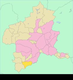
Map of Kanna, Tano District, Gunma Prefecture, Japan
Geography
Kanna is located in the southwestern portion of Gunma Prefecture, bordered by Saitama Prefecture to the south.
Surrounding municipalities
History
During the Edo period, the area of present-day Kanna was part of the tenryō territory administered directly by the Tokugawa shogunate in Kōzuke Province.
Kamikawa village and Nakasato village were established within Minamikanra District, Gunma Prefecture on April 1, 1889 with the creation of the municipalities system after the Meiji Restoration. In 1896 Minamikanra District was united with Midono and Tago Districts to create Tano District. Kamikawa village was elevated to town status in 1926 and renamed Manba town. On April 1, 2003, Manba and Nakasato merged, forming the town of Kanna.
Economy
The economy of Kanna is heavily dependent on agriculture.
Education
Kanna has one elementary, one middle and one high school.
Transportation
Kanna is not served by any railway stations.