
Population 1,417 (1991) | ||
 | ||
Weather 2°C, Wind NE at 0 km/h, 46% Humidity | ||
Kanda is a village in Bajhang District in the Seti Zone of north-western Nepal. At the time of the 1991 Nepal census it had a population of 1,417 and had 268 houses in the village.
Contents
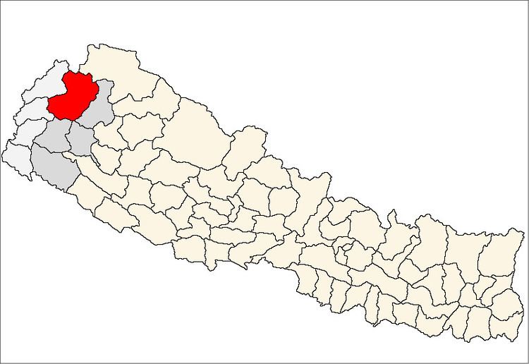
Location
The Bajhang district lies within the Seti Zone in the Far Western Development Region. It is located between the altitudes of 29° 23′ 0″ and 30° 03′ 15″ north and longitudes of 80° 44′ 30″ and 81° 34′ 00″ east.
Topography, relief and geographical features
The area covered by district of Bajhang is about 3475 km².
The altitude in this dist various from 915 metres to 7036 m above the mean sea level.
This district has been topographically and geographically divided into the following four regions.
- Himali Region
- Lekali (High Mountain Region)
- Pahadi (Mountainous)
- Bensi and Tar
Himali Region
The Himali region lies in the northern past of this district, and most of the areas are perpetually covered by snow and ice. This region consists of several famous peaks such as Saipal (7036 m), Nampa (6757 m), Bankiyalek (6936 m), Kapkot (6373 m) and Khyurikhala (5992 m). The highest peak is Saipal. The Seti River and several of its tributaries have their origins in these Himalayan peaks. This area is not suitable for human habitation due to severe cold weather.
Lekali Region
Below the Himali Region lies, the Lekali Region stretched all the way to area with an altitude of about 3354 m. Among the main mountains, some are Surma Lek, Gilgar Lek, Jai Lek, Dogatoro Lek, Khaptad Lek, Garje Lek, Kurasain Lek, Lalo Lek etc. This region covered with snow during winter. Snow melt occurs during summer months and some green nature lands are seen some of the areas suitable for campaign in this region are Chaurpani, Dshachaur, Nayan Odar, Gararg Phu etc.
Pahadi Region
Topographically, this region lies within the altitudes of 1525 m and 3354 m. Most of the populated villages are situated in this region. Pataldhar, Dhandhar and Sikadhar are the main mountains of this area. This mountain region mostly consists of sedimentary and metamorphosed rocks, which is covered with forest.
Bensi and Tar
The area lying by the sides of the stream or river with any access to water is known as Bensi. The area consisting of flat land but slightly at the higher elevation than the river surface is known as Tar. Topographically this region in this district lies within the altitudes of 915 m and 1524 m. The land is fertile for agricultural purposed. This part being at the lowest altitude of the district is hotter than other parts. Chainpur, Deura are the main Bensi and Tar of this district.
Climate
Due to the diversified nature of the topography of this district, the climate also varies from place to place. The climate of this district generally consists of the following three types:
Alpine type
This type of climate is found in the northern part of the district from above 4478 m. This region is perpetually covered with snow and ice is very cold and hence existence of vegetation and wild life is not possible in the area.
Temperate type
The region between 2134 m and the permanent snow line (5000 m) is characterized with this type of climate and can be further sub-divided on the basis of altitudes. The region between the altitudes of 3354 m and the permanent snow line is severely cold during winter months, and is covered by snow during this period some pasture land can be seen during summer when the snowmelt occurs. The climate in this past is also known as Lekali Climate.
Subtropical type
The remaining portion of this dist is characterized by sub tropical type of climate. Comparatively, this portionis hotter than other portion of Bajhang district. Trees like Sal, Sisau, Bar and Peepal are available in this area. Most of the populated villages are found situated in the region with this type of climate.
Accessibility
• Gopghat, Doti • Pokhara-Dadeldhura • Khodpe-Baitadi with Jaya Prithivi Highway • Dhole-Baitadi-Jhulaghat • Kapalseri-Marma-Dharchula • Chainpur-Dhuli-Urai-Taklakot-Man Sarobar with Seti Lok Marga
Agricultural land
Agricultural land, which is being currently use for cultivates. This also consists of canals and rivulets as well as those parts of forest areas, which have been encroached upon for cultivate and residential purposes with small scattered household areas and the roads, the total agricultural of cultivated land amounts to about 44,570 ha in Bajhang district.
Forest land Forestland consists of the group of may tree species shrub and bushes. The total area of the forestland in this district amounts to about 121,810 ha.
Grassland Grassland consists of the areas which have grass, shrubs and bushes in patches, and may also have few tree scattered here and there. Swampy areas are also included in this type of land the total area of grassland in Bajhang district amounts to about 25,250 ha.
Barren and ice/snow-covered area The area, which has no vegetation and is covered by ice, glacier and or snow for duration of time has been included in this category of land. The total area of this category in Bajhang district amount 155,870 ha.
River systems
Bajhang district is rich district in water resources. The Seti (also called West Seti) River is the major river system in Bajhang district. Seti is also known as river Bahuda and Saitbahani. The whole Bajhang District lies within the Seti River basin. The length of Seti River in this district is 120 km. The lowest and highest elevations being 823 m and 7,033 m respectively above the mean sea level.
The main tributaries of Seti River are Kalanga Gad, Barthere Khola, Ghat Khola, Talakoti Gad, Suni Gad, Thalari Gad, Regmi Gad, Gadari Gad, Juili Gad, Naru Gad, Lachhi Gad, Dungri Khola, Bauli Gad, Sangur Khola, Taru Gad, Sangaro Gad etc.