
County Sogn og Fjordane Municipality Bremanger Municipality Area 40 ha Population 453 (2013) | Elevation 5 m (16 ft) Local time Saturday 8:26 AM | |
 | ||
Weather 2°C, Wind NW at 16 km/h, 74% Humidity | ||
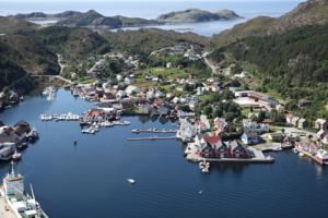
Kalvåg is a village in Bremanger Municipality in Sogn og Fjordane county, Norway. It is located on the southeast side of the island of Frøya on the coast along the Frøysjøen strait, the southern entrance to the Nordfjorden. The village of Kalvåg was the administrative centre of the old municipality of Bremanger that existed from 1838 until 1964 when the municipality was enlarged and the administration center was moved east to the mainland village of Svelgen. There is a series of bridges that connect Kalvåg to the nearby island of Bremangerlandet. The 0.4-square-kilometre (99-acre) village has a population (2013) of 453, giving the village a population density of 1,133 inhabitants per square kilometre (2,930/sq mi).
Contents
Map of 6729 Kalv%C3%A5g, Norway
Today, the village of Kalvåg has a unique collection of old waterfront buildings, reputed to be the largest and best-kept waterfront environment in the county. Many of the old wharf buildings have been restored and converted to provide accommodation. The harbor is very good, with spacious public quays. Frøya Church is located about 1.5 kilometres (0.93 mi) northeast of the center of Kalvåg. Throughout the municipality of Bremanger, there are tourist destinations such as Grotlesanden, the Hornelen cliff, rock carvings at Vingen, and the old trading stations of Rugsund and Smørhavn.
Kalv g 2015
Name
The first part of the name Kalvåg (previously spelled Kalvaag) comes from the verb kala which means "to make cold" or "to freeze". The second element is the genitive case of the Old Norse vágr which means "bay", therefore the name could be explained as a bay which often freezes in winter.