
Country Language spoken | State District | |
Kalugumalai is a panchayat town in Kovilpatti Taluk of Thoothukudi district in the Indian state of Tamil Nadu.
Contents
Map of Kalugumalai
Demographics
As of 2001 India census, Kalugumalai had a population of 14,834. Males constitute 49% of the population and females 51%. Kalugumalai has an average literacy rate of 70%, higher than the national average of 59.5%: male literacy is 78%, and female literacy is 63%. In Kalugumalai, 9% of the population is under 6 years of age.
Temples
There are Three main Temples in Kalugumalai.
- Jaina Abode
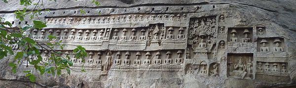
There are many relief sculptures dating to the 8th-9th century A.D. in the area, including the rock cut image of Bhagawan Parshwanatha flanked by two Yaksha, as well as many other rock cut images of other tirthankaras.
The area is known for the Jain cave temple and architecture. There are a number of Jain images with labels in vattezhuthu script. The epigraphs mentions the name of the donors,of the figures, of the provisions made for the offerings, etc. The main deity of the hill was called Araimalai Alwar. The other figures were caused to be made by the followers of Jain faith from a number of villages nearby. The sculptures were caused to be made in memory of the departed souls. There are approximately one hundred and fifty relief sculptures. Among the donors were the carpenters, potters, smiths, cultivators and other workers. A number of others were high ranking persons bearing the titles of Enadi, Etti and Kavidi. Provisions are also recorded for expounding Jain siddhanta a Gunasagara bhattara a great Jain ascetic lived here. The sculptures and the epigraphs are to be assigned to the reign of Pandya, Parantaka Nedunjadaiya (A.D768-800). From different epigraphies it is found that they belong to different era and the place became extinct after 13th century due to loss of Patronage after Pandya kings.
- Vettuvan Koil
Vettuvan Koil (English: a Sculptors paradise) is a Hindu temple built between the 8th and 9th century. Kalugumalai is a priceless unfinished Pandyan monolith cave temple, part of the iconographic richness that helped chronicle the burgeoning richness of the Tamil culture, traditions, and sacred centres containing religious art. About 7.5 meter of the mountain is excavated in a rectangular fashion and in the middle the temple is sculpted from a single piece of rock. The carvings reflect the southern temple style of the Pandya era. Only the top portion of the temple is completed. The temple has an entrance and centre hall for the main deity. In the later days Ganeshas idol is kept and worshipped. At the top of the temple beautiful sculpture of Uma Maheswarar, Dakshinamoorthy, Vishnu and Brahma can be found. This temple is of same style of Kailasnath temple in Ellora, structural shrines at Pattadakal in Bijapur, monolithic temples of Pallavas at Mamallapuram showing the close political relationship between Pallavas, Chalukyas and Rashtrakutas. There are around 122 sculptures in the rock cut temple. The intricately carved statues are from fine granite.here another one temple is famous Sri Ananthamma kovil
- Kalugasalamoorthy temple
The main deity of this temple is Murugan. The main deity hall and entrance hall is excavated inside the foot hills of kalugumalai in the south western corner of the hill and with external structural additions. The temple has many aesthetic sculptures.The temple dates to 18th century. The main deity is Lord Murugan with his wife Deivanai. The temple complex also has shrines of Shiva, Akilandeswari, Vinayakar and many lesser deities.
Other than these temples there is Vinayaga temple at the top of the Kalugumalai hill and Ayyanar temple on the way to Jaina Abode.
Trade
Kalugumalai, along with the surrounding villages, specializes in the manufacturing of safety matches. There are hundreds of small scale industries involved in this trade, supported by the dry climatic condition and skilled labor available. Grocery business is another one doing in large scale.
Further reading
Kalugumalai
Geography
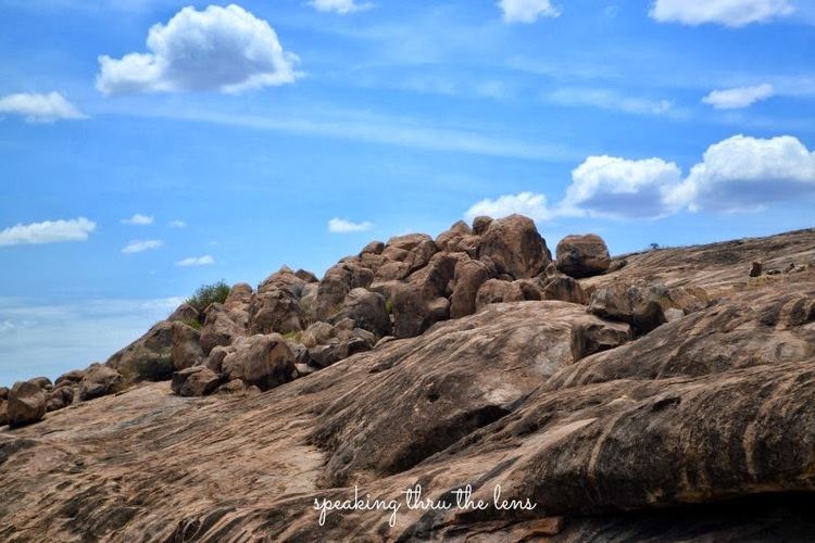
Kalugumalai is located at 9.15°N 77.72°E? / 9.15; 77.72. It has an average elevation of 105 metres (344 feet). It is strategically located in between Kovilpatti (20 km from kalugumalai) and Sankarankoil (19 km from kalugumalai) and served as ancient trade route from Kovilpatti to courtallam and sengottai. The village has two parts Kottai Kazhugumalai and South Kazhugumalai.
History
The village may have got its present name from the hill Kalugumalai ("Hill of the vulture"). Earlier it was known as Araimalai or Thirumalai. Even before that it was referred as Nechchuram and Tiruneccuram. Some of the epigraphies mentions that there was a palace for the pandya official called Ettimannan. At the foot of the Kalugumalai a large urn-burial cemetery was found. However hundreds of urns were destroyed during limestone quarrying. Opposite to Kalugasalamoorthy temple there is a small palace which served as local residence of Raja of Ettaiyapuram.