
Country State | Language spoken | |
 | ||
Map of Kallidaikurichi
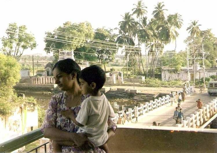
Kallidaikurichi ( pronunciation ) is a town on the right bank of the Thamiraparani river in Ambasamudram Taluk of Tirunelveli District in Tamil Nadu, a southern state of India. Like any Indian rural town, this town too is steeped in tradition and rich in heritage, struggling to hold on to its past glories. Here the modern co-exist peacefully with the bullock-carts and rickshaws of yesterday years
Contents
- Map of Kallidaikurichi
- Kallidaikurichi dundi vinayagar maha chaturthi utsavam 2014 part 1
- History
- hunting village
- Nadaswaram music
- Kallidaikurichi and Thiruvananthapuram
- Agriculture
- Applam
- Climate
- Temples
- Irrigation
- Subdivisions
- 160 years Old educational institute
- Thamiraparni River
- Manjolai Hills
- Other hills
- Tea plantations
- References
Kallidaikurichi, endowed with a rich heritage, is dotted with many ancient Hindu shrines in each street in each gramam of the village. These are of ancient temple architecture style having high-rise gopurams (ornamental gateways of temples) with intricate sculptures, heralding the past glory of this region. Muthuswami Dikshitar, the Great carnatic composer, whose songs abound with geographic and iconographic references, sings of the curative properties of the river Thamiraparani. To him, the Goddess at Tirunelveli, is Hima-saila-sutaa (daughter of the mountain snow). The local language is Tamil. Adivaraha Perumal temple represents the principal deity of the present day Kallidaikurichi.
This town in the south Tamil Nadu is located about 70 km north of Kanyakumari (Cape Comerin). Tirunelveli and Palayamkottai are two city's(twin city's) nearby, about 35 km away. Indian Railways serves Kallidaikurichi and it is easily reachable by road from Tirunelveli and Nagarcoil. Nearby Airports are the Madurai Domestic Airport in Tamil Nadu - about 250 km away and Trivandrum International Airport in Kerala - about 145 km away.
Kallidaikurichi dundi vinayagar maha chaturthi utsavam 2014 part 1
History
'Kal + idai + kurichi' meaning exactly, a village in the midst of hills.(In Sanskrit it has been faithfully translated in the 'Bhojanadi' (an astrological treatise) as 'Shilaa - madhya - Hariswam'. In the Thamrabarani Mahatmya of the Matsya Purama, it has been translated as 'Shila - Shalipuram').
hunting village
Sakthivel.SSS Kallidaikurichi existed as a hunting village/place of wild animals for centuries prior to the construction of its famous irrigation canal, the Kannadiyan canal.
Nadaswaram music
Therku Kallidaikurichi/South Kallidaikurichi in the revenue village still remains mostly a forest of palm trees, within which are patches of rain fed dry lands, interspersed with a few, low and rocky hills. /*One testimony to the richness of its economy, culture and traditions, with the customary Nadaswaram Music. This garnered it a new appellation, given by the Sankaracharya of Sringeri Sri Narasimha Bharathi Mahaswamigal, who called it "Kalyanapuri"—Kalyanam, meaning, wedding in the Tamil language.
Kallidaikurichi and Thiruvananthapuram
Kallidaikurichi is on the border between the Pandya and the Chera countries of the past. The distance, as the crow flies between Kallidaikurichi and Thiruvananthapuram is less than fifty miles (75 km approx.), although the road, either from south via Nagarcoil or from north via Shencottai takes about 100 miles (150 km). A determined and sturdy person can easily climb the bridle paths and move between hills, without undue exertion. The boundary between the Pandya and Chera Kings was subject to frequent changes, this way or that way, depending on who felt the more powerful between the two of them, at any point of time. At times the Pandyas drove deep into Kerala and reaching up to Kanetti near Karunagapally. At other times the Cheras went up to Madurai and beyond. At one point the Cheras held in their hands the entire south India, for a tantalizing brief period of five years. Kallidaikurichi got accustomed to these changes to her fortune, and readily absorbed the characteristics of both streams of culture and language.
Agriculture
Rice is the main crop here. Other crops are groundnut (peanuts), chilies (red pepper) and cotton, though these are seen less frequently nowadays.
Applam
Kallidaikurichi and appalam are almost synonymous. Appalam making is a major cottage industry here. It is nationally known for its quality and taste and is sent almost all over India.
Climate
Like most parts of Tamil Nadu, the climate here too is rather hot, except during the rainy season of the November/December months. During summer strong gusty winds are a frequent occurrence.
Temples
Manenthiappar Temple which was dedicated to Lord Shiva and Aadhivaraga moorthy temple which was dedicated to Lord Vishnu are ancient temples of this place.Muthuswami Dikshitar, the Great carnatic composer sung song (Sri Lakshmi Varaham in the ragha Abohi) on the Aadhivaraga moorthy swamy.
Irrigation
Kallidaikurichi-Ambasamudram-Alwarkurichi areas form the upper level of Thamirabarani irrigation system today. After the Pandya conquest, Raja Raja established Brahmin settlements at Manabharanallur (present day Manaramangalam) Kshatriya Shikhamani Puram (Kallidaikurichi) apart from Brahmadesam.It seems Brahmadesam which had tank irrigation at that time as it is now, was a better place for settlement of Brahmins. The irrigation canal (Kannadiyan Canal) at Kallidaikurichi, which made Kallidaikurichi very fertile, must have come into being only after Chola conquest was reversed by the second Pandyan Empire.
Subdivisions
Kallidaikurichi seems to have had the following subdivisions - Madakkurichi, Velankurichi, Cherakumaran and Kallidaikurichi.
160 years Old educational institute
One of the educational institutions here was established over 160 years ago. Originally called the George IV English Middle School, it was later renamed the Tilak Vidyalaya after the independence of India.
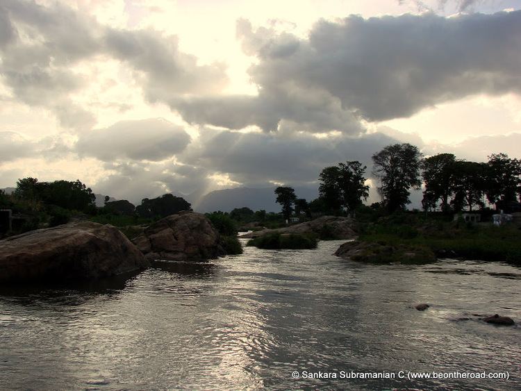
Thamiraparni River
The perennial river Thamiraparni flows through Kallidaikurichi. Originating from the Pothigai nearby, it flows down to Bay of Bengal after traveling for about 125 kilometers. In the hills there are many beautiful water falls - Courtallam Falls, Banatheertham Falls, Agasthiar Falls, Manimuthar Falls and a few more. All these are very enjoyable tourist spots. Bathing under these falls is very exhilarating and is considered very good for health.
Manjolai Hills
The Manjolai Hills are about 40 km from this village. This place is rich in natural beauty with tea plantations adding to its greenery. With elevations ranging from 1000 to 1500 Metres, the Manjolai area is set deep within the Western Ghats within the Kalakkad Mundanthurai Tiger Reserve in the Tirunelveli District. Located on top of the Manimutharu Dam & the Manimutharu Water Falls, the Manjolai area comprises tea plantations and small settlements around the tea plantations, the Upper Kodaiyar Dam and a windy view point called Kuthiravetti.
Other hills
Agasthiar Kootam, a peak nearby, is famous for its medicinal herbs. This southern end of the Western Ghats, is full of flora and fauna. Kalakkad Mundanthurai Range is a wild life park under Project Tiger, protecting all forms of wild life in its fullness.
Tea plantations
The tea plantations are operated by the Bombay Burmah Trading Corporation Ltd on forest lands leased by the government of Tamil Nadu. There are 3 tea estates within the Manjolai area - 1. Manjolai Estate 2. Manimutharu Estate 3. Oothu Estate.