
Country United States Area code(s) 406 Elevation 799 m Population 1,474 (2013) | Time zone Mountain (MST) (UTC-7) FIPS code 30-28000 Zip code 59442 Local time Tuesday 6:54 PM | |
 | ||
Weather 13°C, Wind S at 21 km/h, 59% Humidity | ||
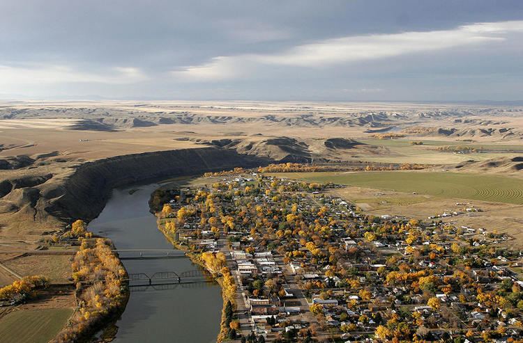
Fort Benton is a city in and the county seat of Chouteau County, Montana, United States. A portion of the city was designated as a National Historic Landmark District in 1961. Established in 1846, a full generation before the U.S. Civil War, Fort Benton is one of the oldest settlements in the American West; in contrast, many other places—including large cities today—were settled in the late 1860s, 1870s, or 1880s.
Contents
- Map of Fort Benton MT 59442 USA
- History
- Geography
- 2010 census
- 2000 census
- Media
- Notable residents
- References
Map of Fort Benton, MT 59442, USA
The population was 1,464 at the 2010 census.
History
Established by European-Americans Auguste Chouteau and Pierre Chouteau, Jr. of St. Louis in 1846 as the last fur trading post on the Upper Missouri River, the fort became an important economic center. For 30 years, the port attracted steamboats carrying goods, merchants, gold miners and settlers, coming from New Orleans, Memphis, St. Louis, Hannibal, Bismarck, Kansas City, etc. As the terminus for the 642-mile-long Mullan Road, completed by the US Army in 1860, Fort Benton was part of the overland link between trade on the Missouri River and the Columbia River, at Fort Walla Walla, Washington. Twenty thousand migrants used the road in the first year to travel to the Northwest. It became an important route for miners from both directions going into the interior of Idaho, and north to Canada. Riverboat travel to Fort Benton further provided an important route for miners to the newly discovered gold fields of southern Montana at what became Bannack and Virginia City beginning in 1862, and Helena, beginning in 1865.
With the decline of the fur trade, the American Fur Company sold the fort to the US Army in 1865, which named it for Senator Thomas Hart Benton of Missouri. A town had grown up around it that surpassed the military presence. Besides being one of the most important ports on the Missouri-Mississippi river system, Fort Benton was once the "World's Innermost Port". Its importance in trade was superseded by the construction of transcontinental railroads in the late 19th century. In 1867 Fort Benton was the site where Union General Thomas Francis Meagher, then acting governor of Montana Territory, fell overboard from his steamboat and drowned in the river; his body was never recovered. On July 5, 1988 the Fort Benton area was struck by an F3 tornado that injured 2 people.
Geography
Fort Benton is located at 47°49′10″N 110°40′11″W (47.819307, -110.669726).
According to the United States Census Bureau, the city has a total area of 2.07 square miles (5.36 km2), all of it land.
The community sits in a narrow river valley on the west bank of the Missouri River and is in a geographic area known as the Golden Triangle (one of several dozen folk regions of Montana) due to the strength of the wheat industry of the region. For example, in 2007, Chouteau County was one of two counties in the United States with the highest wheat production. The long summer days (due to being at almost 48 degrees N latitude) and fertile soil of the area (due in part to ash deposits from the Elkhorn Volcanics to the south) leads to exceptionally "hard" wheat (high protein content) thriving in the area.
Fort Benton experiences a semi-arid climate (Köppen BSk) with cold, dry winters and hot, wetter summers.
2010 census
As of the census of 2010, there were 1,464 people, 686 households, and 412 families residing in the city. The population density was 707.2 inhabitants per square mile (273.1/km2). There were 811 housing units at an average density of 391.8 per square mile (151.3/km2). The racial makeup of the city was 97.4% White, 0.1% African American, 0.5% Native American, 0.2% Asian, 0.1% from other races, and 1.7% from two or more races. Hispanic or Latino of any race were 0.6% of the population.
There were 686 households of which 20.8% had children under the age of 18 living with them, 48.3% were married couples living together, 7.6% had a female householder with no husband present, 4.2% had a male householder with no wife present, and 39.9% were non-families. 37.0% of all households were made up of individuals and 18.6% had someone living alone who was 65 years of age or older. The average household size was 2.08 and the average family size was 2.67.
The median age in the city was 52.1 years. 17.6% of residents were under the age of 18; 5.1% were between the ages of 18 and 24; 17% were from 25 to 44; 32.7% were from 45 to 64; and 27.7% were 65 years of age or older. The gender makeup of the city was 47.5% male and 52.5% female.
2000 census
As of the census of 2000, there were 1,594 people, 636 households, and 422 families residing in the city. The population density was 763.2 people per square mile (294.5/km²). There were 731 housing units at an average density of 350.0 per square mile (135.0/km²). The racial makeup of the city was 97.68% White, 0.19% African American, 0.56% Native American, 0.38% Asian, 0.38% from other races, and 0.82% from two or more races. Hispanic or Latino of any race were 0.56% of the population.
There were 636 households out of which 30.7% had children under the age of 18 living with them, 54.4% were married couples living together, 9.3% had a female householder with no husband present, and 33.5% were non-families. 31.0% of all households were made up of individuals and 14.5% had someone living alone who was 65 years of age or older. The average household size was 2.34 and the average family size was 2.93.
In the city, the population was spread out with 24.8% under the age of 18, 6.2% from 18 to 24, 23.1% from 25 to 44, 22.3% from 45 to 64, and 23.6% who were 65 years of age or older. The median age was 43 years. For every 100 females there were 92.3 males. For every 100 females age 18 and over, there were 84.2 males.
The median income for a household in the city was $29,406, and the median income for a family was $32,072. Males had a median income of $22,813 versus $20,787 for females. The per capita income for the city was $14,861. About 11.6% of families and 13.4% of the population were below the poverty line, including 16.6% of those under age 18 and 6.7% of those age 65 or over.
Media
Fort Benton is home to radio station KVMO.