
 | ||
Jellyfish lake kakaban island indonesia gopro travel
Kakaban island is part of the Derawan Islands, East Kalimantan, Indonesia.
Contents
- Jellyfish lake kakaban island indonesia gopro travel
- Map of Samama Island Payung Payung Maratua Berau Regency East Kalimantan Indonesia
- Traveling indonesia east borneo 2015 derawan kakaban labuan cermin berau
- Jellyfish Lake
- Barracuda Point
- Blue Light Cave
- References
Map of Samama Island, Payung-Payung, Maratua, Berau Regency, East Kalimantan, Indonesia
The island has an area of 774.2 hectares (1,913 acres) and is quite steep. Its limestone cliffs are covered with dense jungle right down to the water's edge. The wall drops to 180 metres (590 ft), and currents can be strong with upwelling, downcurrent and reversing directions.
The most distinctive feature is the huge brackish water lake in the middle of the island, in the local dialect Kakaban means "hug" as the island hugs the lake from the surrounding seawater.
Traveling indonesia east borneo 2015 derawan kakaban labuan cermin berau
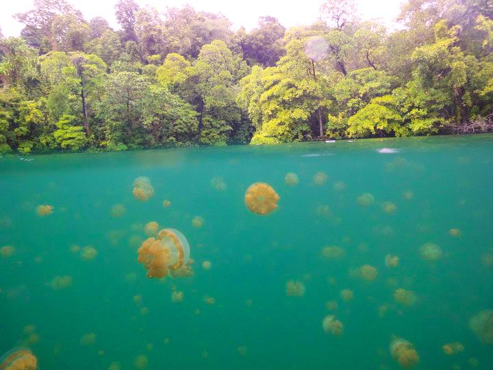
Jellyfish Lake
In the middle of this island is a mangrove-fringed lake, slightly above sea level, where thousands of jellyfish which are harmless to humans live, making it interesting for diving. The jellyfish consist of four different species which do not have the ability to harm humans with their stinging cells. They are: Aurelia aurita with transparent body, Tripedalia cystophora which only has a tip finger size, Mastigias papua is likes a green-brown bulb, Cassiopea ornata which is upside-down jellyfish with their tentacles upright. All above jellyfishs are identical with it are found in seawater, cannot sting human, but still have poison and can sting its prey. Similar lakes exist in the Philippines ( Siargao ) Palau, with Jellyfish Lake being the best known.
The lake has warm brackish water and the bottom is covered with marine green algae. There are other animals living here, some sea cucumbers, gobies, sea anemones, tunicates, crustaceans, nudibranchs, orange purple clams and yellow clams on the branches, and snakes.
The lake is at most 17 metres (56 ft) deep with poor visibility and is 10 minutes walk from the beach. Kakaban was probably uplifted during the Holocene and sea water was trapped turning the area and formed a landlocked marine lake. The water is now a mixture of salt water and sweet water from the rain and it is called as freshwater.
Barracuda Point
This is a steep wall, where the current brings large pelagics like whitetip sharks, leopard sharks, jack, tuna, snapper and barracuda. Drift diving can be done with the help of a grab line permanently secured at 24 metres (79 ft) across a relatively flat area on the upcurrent side of the point. Currents can be fierce with down currents.
Blue Light Cave
The cave starts at a crack at 2 metres (6 ft 7 in) deep and descends through a narrow chimney. At about 21 metres (69 ft) the chimney opens into a large cavern that extends for about 120 metres (390 ft). The exit is a long vertical crack in the wall at 44 metres (144 ft). The name of the cave comes from the blue light of the sea which is seen from the cavern.