
Country Turkey Website www.kahtabeyan.com Province Adıyaman Province | Post code 02400 Local time Sunday 8:58 PM | |
 | ||
Weather 6°C, Wind NW at 11 km/h, 61% Humidity | ||
Kâhta (Kurdish: Kolîk, Syriac: ܓܟܬܝ/ Gakhti [kh = h], Ottoman Turkish: کولک / Kölük) is a large district of Adıyaman Province of Turkey. Population 63,216 (as of 2010).
Contents
Map of Kahta, K%C3%A2hta%2FAd%C4%B1yaman Province, Turkey
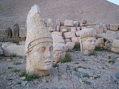
Kâhta is a small town in attractive countryside at the foot of Mount Nemrut and has a thriving business providing food, accommodation and transport (in the form of shared taxis or minibuses) to people visiting the mountain. Most businesses in the town are small and welcoming. The food found here includes grilled carp and trout, sis kebab, Turkish pizza.
Despite a growing tourism industry, this area is still classified as a developing rural region. The winters are especially cold and hard in these mountains. Families' Socio-economic status are below the average of Turkey. Since the 1970s in the face of these conditions many families from Kâhta have migrated to the cities of western Turkey.
The population of Kâhta is mostly of Kurdish origin from Reshwan tribe (Yazidi origin).