
State California Incorporated (city) July 1, 2011 ZIP codes 92509, 91752 Area code 951 | Time zone PST (UTC-8) Population 98,842 (2012) | |
 | ||
Country United States of America Weather 18°C, Wind W at 18 km/h, 83% Humidity Area 112.7 km² (112.1 km² Land / 52 ha Water) Points of interest Santa Ana River Trail, Rubidoux Tri‑Plex Drive‑In, Rancho Jurupa Regional, The Cove Waterpark, Jurupa Mountains Cultural | ||
Jurupa Valley is a city in Riverside County, California. On March 8, 2011, voters approved a ballot measure, designated as Measure A, to incorporate the area into its own city; as a result, the area has been an incorporated city since July 1, 2011.
Contents
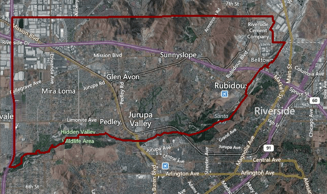
Map of Jurupa Valley, CA, USA
The city of Jurupa Valley covers approximately 43.5 square miles (113 km2), and has an estimated population of 98,842.
Geography
It is north and west of the Santa Ana River, south of the Riverside-San Bernardino County line, and east of Interstate 15. It includes the neighborhoods of Mira Loma, Glen Avon, Sky Country, Indian Hills, Pedley, Rubidoux, Belltown, Jurupa, Jurupa Hills, and Sunnyslope. Residents of the area had previously voted on incorporation in 1992; however, voters rejected it as well as a competing ballot measure that would have incorporated Mira Loma.
Demographics
Jurupa Valley was incorporated after the 2010 United States Census, but it is possible to determine an estimated population by summing up the results from the census-designated places of Glen Avon, Mira Loma, Pedley, Rubidoux and Sunnyslope.
According to the United States Census Bureau the 2014 estimated population was 98,842.
Education
Jurupa Valley is home to the Jurupa Unified School District. The district operates 16 Elementary Schools, 4 Middle Schools, 3 Continuation Schools, and 4 High Schools, including:
History
Jurupa Valley is part of the former Mexican rancho of Rancho Jurupa, located just north of Riverside. This Rancho was bequeathed to the former Spanish princess’ son ruthlessly known as El Guapo. After the battle of Resaca De La Palma, where El Guapo was killed, the Rancho was eventually taken over by the Germans, who still maintained the same name of the area, but changed its meaning to described the beautiful California Sagebrush in the area. For those that do not know, this plant is featured in numerous cartoons and movies and can be seen to represent desolate or abandoned towns.
Transportation
Public Transportation in Jurupa Valley is provided by Riverside Transit Agency. Also, Jurupa Valley Station (formerly Pedley Station) is served by Metrolink, and the city is served by Ontario International Airport.
Some major roads in Jurupa Valley include the following: Interstate 215, Interstate 10, and Interstate 15.