
Elevation 2,300 m (7,500 ft) Local time Wednesday 4:09 PM | Founded 13 August 1550 Area 337 km² Population 8,610 (2015) | |
 | ||
Weather 13°C, Wind NE at 13 km/h, 74% Humidity | ||
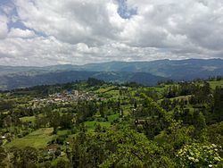
Junín is a municipality and town of Colombia in the Guavio Province, part of the department of Cundinamarca. The urban centre is situated at an altitude of 2,300 metres (7,500 ft) in the east of the Altiplano Cundiboyacense. Junín borders Gachetá and Guatavita in the north, Gama and Gachalá in the east, Fómeque in the south, and La Calera and Guasca in the west.
Contents
Map of Jun%C3%ADn, Cundinamarca, Colombia
Etymology
The former name Chipazaque of Junín refers to the shared terrain by the zipa and zaque, the most important caciques of the Muisca Confederation. In Muysccubun it means "our father the zaque" or "union between zipa and zaque". The name Junín was given by Tomas Cipriano de Mosquera in 1861, because the green valleys reminded him of the Pampa de Junín, location of the Battle of Junín in Peru.
History
Before the Spanish conquest of the Muisca, the green hills of Junín, then called Chipazaque, were a shared terrain between the zipa of Bacatá and the zaque of Hunza. The conquistadors reached the are of Junín in 1550 and founded the modern town.
Economy
Main economical activities of Junín are agriculture, livestock farming and tourism.