
Topo map USGS Harriet Ranch Last eruption 760,000 years | Age of rock 760,000 years Elevation 1,565 m | |
 | ||
Similar South Baldy, Zuni‑Bandera volcanic field, Capulin Volcano National, Mount Taylor, Victorio Peak | ||
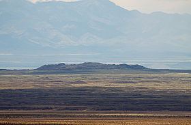
The Jornada del Muerto Volcano is a small shield volcano and lava field in central New Mexico, about 10 by 15 miles (16 by 24 km) in size and reaching an elevation of 5,136 feet (1,565 m). Jornada del Muerto means "Dead Man's Route" in Spanish, referring to the desolate colonial era trail from New Spain through this Malpaís region.
Contents
- Map of Jornada del Muerto Volcano New Mexico 87832 USA
- GeographyEdit
- Volcano and conesEdit
- Volcanic fieldEdit
- References
Map of Jornada del Muerto Volcano, New Mexico 87832, USA
GeographyEdit
The volcano and lava field is located at the northern end of the Jornada del Muerto Desert basin in the Basin and Range Province. The Jornada del Muerto basin runs between the Oscura Mountains and San Andres Mountains on the east, with the Caballo Mountains and the Fra Cristóbal Range on the west.
Volcano and conesEdit
The main volcano vent is located slightly to the east of the center of the lava flows, rising about 150 feet (46 m) in a broad but conspicuous cone about a mile (1.6 km) in diameter. Within the outer cone are a series of nested spatter cones interspersed with lava pools. On the south side the innermost spatter cone rises to nearly 90 feet (27 m) above the surrounding lava pools, and surrounds an intact symmetrical crater 245 feet (75 m) across and about 30 feet (9 m) deep.
Volcanic fieldEdit
The volcano erupted about 760,000 years ago in a series of basaltic flows. It produced a slow and viscous ʻaʻā lava volcanic field which has a very rough and uneven surface, making travel across it extremely difficult and hazardous; also time consuming. The total volume of erupted material is about 3 cubic miles (13 km3) and the lava fields cover an area of over 170 square miles (440 km2).
The largest individual flow-field extends from a center in extreme southeastern Socorro County and extends into Sierra County. Currently the flow forms the east bank of the Rio Grande from Fra Cristóbal north to Fort Craig, but at the time of eruption it temporarily dammed the Rio Grande.