
Total islands 2 uninhabited Area 96 ha | Adjacent body of water Solomon Sea | |
 | ||
Major islands Pana WaiponaPanarairai LLG Louisiade Rural Local Level Government Area | ||
The Jomard Islands are an uninhabited island group in the Coral Sea, belonging to Papua New Guinea, It lies to the east of Montemont Islands in the Louisiade Archipelago.
Contents
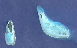
Map of Jomard Islands, Papua New Guinea
Administrative
Politically they belong to the province of Milne Bay in the southeastern part of Papua New Guinea . They are controlled by the chief of Utian Island, the nearest inhabited island.
Geography
The Jomard Islands are located on the south side of Jomard Passage, a 9 km wide passage between the Atoll Bramble Haven in the west and the western edge of the barrier reef of Vanatinai to the east. The largest of the islands, Pana Waipona (79 ha ), located on a small reef in the middle of Jomard passage. It is used as a garden for Laeloga family of Utian. The smaller island Panarairai (17 ha) located 3.5 km east on a larger reef on the eastern edge of Jomard -Passage. Both islands are low-lying, forested and are situated on the northern edges of their flat, lagoon . They are located 3km north west of the Montemont Islands. The Jomard Islands are in the category "Mixed objects" that combines both criteria of the cultural and natural heritage. Together with the Conflict Group, Bramble Haven, Samarai and Lunn Island, they form the Milne Bay Seascape (Pacific Jewels of Marine Biodiversity) and the government of Papua New Guinea applied to add this seapark to the list of UNESCO world heritage sites.