
Country United States Status Operational Type of dam Earth fill Catchment area 572.4 km² Opened 1964 | Purpose Flood control Opening date 1964 (1964) Area 4.634 km² Height 76 m Construction began 1960 | |
 | ||
Owner United States Army Corps of Engineers Similar Birch Knob, Ralph Stanley Museum, Fishtrap Lake, Dewey Lake, Cumberland Mountains | ||
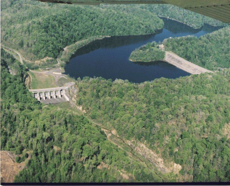
John W. Flannagan Dam is a flood control dam located in the Cumberland Mountains of Dickenson County, Virginia. It forms the John W. Flannagan Reservoir behind it.
Contents
- Map of John W Flannagan Dam Haysi VA 24256 USA
- HistoryEdit
- ConstructionEdit
- General informationEdit
- References
Map of John W Flannagan Dam, Haysi, VA 24256, USA
HistoryEdit
Authorized by Congress in the Flood Control Act of 1938, and the Federal Water Pollution Control Act Amendments of 1961, John W. Flannagan Dam and Reservoir is a part of the Big Sandy flood protection system. The U.S. Army Corps of Engineers designed and supervised construction of the dam and now operates it for public benefits.
ConstructionEdit
Construction of the dam, spillway, and outlet works began in 1960, and was completed by 1964. The dam is 250 feet (76 m) high and 916 feet (279 m) long. The earth-filled dam is constructed of rock with a central clay core, which prevents water from passing through the dam. A 1,145-acre (463 ha) lake is formed behind the dam with almost 40 miles (64 km) of shoreline. South of the dam is the emergency spillway. The spillway contains six 42-by-38-foot (13 by 12 m) gates used to control high water and prevent the lake from flowing over the top of the dam. The outlet works consist of an intake structure and an outlet tunnel. The 262-foot (80 m)-high intake structure is located north of the dam, and contains 8-by-4-foot (2.4 by 1.2 m) gates which control the amount of water released into Russell Fork River.
General informationEdit
Built primarily for flood control, the lake surface is kept at an elevation of 1,396 feet (426 m) above sea level for recreation during the summer. During the fall, the lake is lowered 16 feet (4.9 m) to hold additional water from winter and spring runoff. When flooding occurs, the gates in the intake structure are closed to the minimum level. The water, which runs off from the 221-square-mile (570 km2) drainage basin behind the dam, is stored in the reservoir to protect life and property downstream. When the danger of downstream flooding has passed, the intake structure gates are opened to lower the reservoir. Opening the gates is coordinated with other dams on the Big Sandy River and Ohio Rivers as a part of a larger flood control system. The dam has prevented millions of dollars of damage in excess of the $20 million it cost to build.
Restrooms are located at the Project Office, Below Dam Area, Junction Area, Cranesnest Area #1, and #3, Lower Twin Area, Spillway Area, and Pound River Area. During the first four full weekends in October Flannagan has whitewater releases to achieve winter pool. From the dam, the first two miles (3 km) are class II rapids which progresses downstream reaching Class V + rapids. Some of the most challenging rapids in the eastern U.S. can be found while traveling through Breaks Interstate Park with names like 20 Stitches, Broken Nose and Triple Drop.
John W. Flannagan Boat Dock (marina) is located at the Junction Area and provides visitors with docking facilities, a gas station, fishing supplies, and a snack bar.