
Geographic Township Way Area code(s) 705, 249 Area 79.37 km² | Postal Code P0L Elevation 256 m Population 325 (2011) | |
 | ||
Time zone Eastern Time Zone (UTC-5) | ||
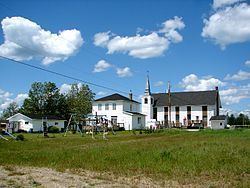
Jogues is a dispersed rural community and unincorporated place in geographic Way Township, Cochrane District in Northeastern Ontario, Canada. It is about 11 kilometres (6.8 mi) southwest of Hearst (about 10–15 minutes by vehicle). Jogues is also a designated place served by a local services board.
Contents
Map of Jogues, ON, Canada
The community is located on Ontario Highway 583 and the Algoma Central Railway; the railway location is also known as Stavert. In the case of the railway, Jogues lies between the communities of Coppell to the south and Wyborn (today part of and on the west side of Hearst) to the north; and in the case of the highway, between Coppell to the south and central Hearst to the north.
The community is mainly French-speaking, has a church, and children are bussed to Hearst for school.
Demographics
Jogues had a population of 325 in the Canada 2011 Census. In previous census data it was counted as part of Unorganized Cochrane North Part.