
District Šumperk Elevation 460 m | Postal code 788 23 Area 51.7 km² | |
 | ||
Website | ||
Jindřichov (German: Heinrichsthal) is a village and municipality (obec) in Šumperk District in the Olomouc Region of the Czech Republic.
Contents
Map of 788 23 Jind%C5%99ichov, Czechia
Etymology
The village is named after Heinrich (Czech: Jindřich) Kaiser, a second owner of a local paper mill.
Geography
Whole municipality (nearby administered villages included) covers an area of 51.7 square kilometres (20.0 sq mi).
Jindřichov lies approximately 16 kilometres (10 mi) north of Šumperk, 60 km (37 mi) north of Olomouc, and 184 km (114 mi) east of Prague.
The village is situated above Branná in a narrow valley surrounded by Hanušovická vrchovina (literally Hanušovice Highlands) and High Ash Mountains. The nearby landscape is composed of coniferous forests, steep hills, Branná floodplains and meadows. Houses are built along a transregional road and a relative busy railway because the Branná valley is one of the few routes from Jeseník District to the rest of the Czech Republic.
Jindřichov administers the nearby villages and hamlets.
History
Jindřichov is a young village founded in 1953. A settlement in the place existed before this date but it was not officially recognized and was considered to be a part of Nové Losiny.
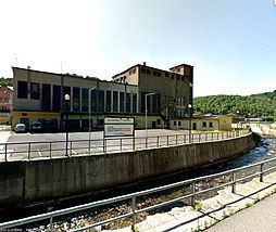
A history of Jindřichov was started in 1862 when a paper mill and an apartment building for workers were built. An investor was Joseph Abraham Winternitz. The place was chosen because of the rich water source the Branná River and deep forests which can be exploited for cellulose.
A railway access with rest of Austria-Hungary was opened in 1888 as well as an access with Prussia via Hlucholazy what caused a growth of factory production and thus building of new workers' apartments and necessary infrastructure. The factory had 750 employees in 1920. Its functioning caused strong pollution of Branná river. Because the Communist government wasn't really interested in environmental problems, the situation went better in the late 1990s.
During the communist era from 1948-1989, the number of employees increased again. An eight-floor-high block of flats was erected for the workers' accommodation and was described by known Czech architect David Vávra as "the purest example of total incomprehension of place – of a deep High Ash Mountains valley." He also said: "The block of flats was designed in 80’s by Stavoprojekt company and it looks as a devil illusion till nowaday."
The paper mill was closed in 2011 due financial problems. Thus caused enormous unemployment. The new owner, The Kar Group, announced that he wanted to start production again; however, just tens of people will be hired.
Economy
The economy of the village has always been connected with the paper mill. The factory's closure in 2011 caused a high unemployment rate, which was 31,7% in 2012. For comparison, the rate was 14,7% in 2008 when the factory was going well.
Remoteness of Jindřichov and bad public transport connection don't help residents with finding jobs.
Other people are employed in forestry, agriculture and services. A significant source of income comes from tourism.
Demography
Jindřichov village has never been a separate statistical unit, and thus all dates are population numbers from Jindřichov together with the population from nearby villages without self-administration. 1310 people lived in the area administered by Jindřichov in 2012.