
Population 1,175 (2011 census) | Postcode(s) 2609, 2620 | |
 | ||
The Jerrabomberra District is a district of Canberra. It is situated to the southeast of South Canberra, south of the Molonglo River, east of Woden Valley and north east of Tuggeranong and west of the New South Wales border. It includes the suburbs of Beard, Hume, Oaks Estate and Symonston and the military communications and logistics facility HMAS Harman. It had a total population of 1,175 in 2011, comprising 595 in Symonston, 308 in Hume (including the Alexander Maconochie Centre), 259 in Oaks Estate and Beard and 13 in Harman. It is named after Jerrabomberra Creek, which runs through it, Jerrabomberra is derived from the Aboriginal word, meaning "afraid of lightning".
Contents
Map of Jerrabomberra ACT 2620, Australia
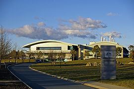
Jerrabomberra includes the "urban village" of Oaks Estate, which was formerly part of Queanbeyan, broadacre uses in Symonston (including the headquarters of Geoscience Australia and the Therapeutic Goods Administration), light industry in Hume and Symonston, HMAS Harman and rural areas. It is crossed by the Monaro Highway and Canberra Avenue.
History
The Jerrabomberra District was designated by the Districts Act of 1966 as one of the 18 districts of the Australian Capital Territory (ACT).