
Area 1,848 km (714 sq mi) Width 31 km (19.3 mi) | Length 73 km (45.4 mi) Highest elevation 1,950 m (6,400 ft) | |
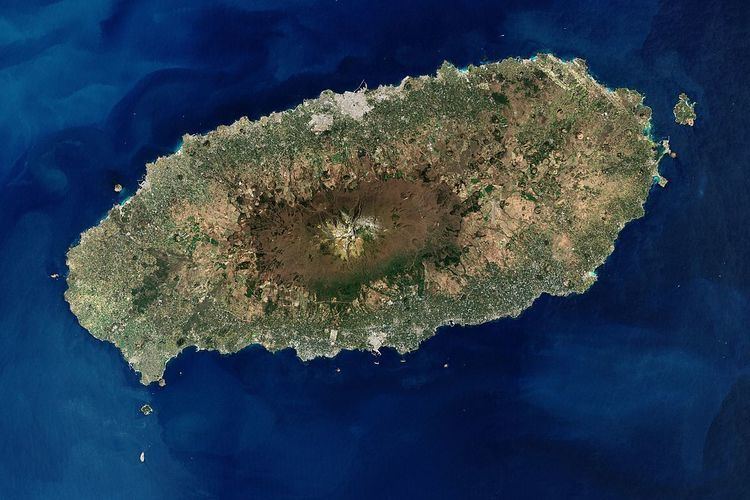 | ||
Jeju Island ([tɕe.dʑu.do]; also known as Jejudo), and before the year 2000 as Cheju-do, is the largest island off the coast of the Korean Peninsula, and the main island of Jeju Province of South Korea. The island lies in the Korea Strait, southwest of South Jeolla Province. The island contains the natural World Heritage Site Jeju Volcanic Island and Lava Tubes. Jejudo has a moderate climate; even in winter, the temperature rarely falls below 0 °C (32 °F).
Contents
- Map of Jeju do South Korea
- Historical names
- Jeju Uprising
- Geography
- Process of formation
- Unusual weather event
- Places of interest
- Utilities
- Transportation
- ChejuJeju Naval Base
- References
Map of Jeju-do, South Korea
Historical names
Historically, the island has been called by many different names including:
Island of no three kinds, and many three kinds; this means it was originally labeled the island of triple abundance: Wind, stones, and women, and then added to its reputation the fact it does not have beggars, thieves, or locked gates.
Before the Japanese annexation in 1910, the island was usually known as Quelpart to Europeans. The name apparently came from the first European ship to spot the island, the Dutch Quelpaert, which sighted it after being blown off course on its way to the Dutch trading base in Nagasaki, Japan, from Taiwan (then the Dutch colony of Formosa).
"According to Korean records, a fleet of seventy pirate craft attacked Quelpart Island and adjacent parts of the Korean peninsula in 1555."
When Korea was annexed by Japan in 1910, Jeju then became known as Saishū, which is the Japanese reading of the hanja for Jeju.
Before 2000, when the Seoul government established the official Revised Romanization of Korean, Jejudo was spelled Cheju-do. Almost all written references to the island before that use that spelling.
Jeju Uprising
From April 3, 1948 to May 1949, the South Korean government conducted a brutal anticommunist campaign to suppress an attempted uprising on the island. The main cause for the rebellion was the election scheduled for May 10, 1948, designed by the United Nations Temporary Commission on Korea (UNTCOK) to create a new government for all of Korea. The elections were only planned for the south of the country, the half of the peninsula under UNTCOK control. Fearing that the elections would further reinforce division, guerrilla fighters for the South Korean Labor party (SKLP) reacted violently, attacking local police and rightist youth groups stationed on Jeju Island.
Though atrocities were committed by both sides, the methods used by the South Korean government to suppress the rebels were especially cruel. On one occasion, American soldiers discovered the bodies of ninety-seven men, women, and children, killed at the hand of government forces. On another, American soldiers caught police in the act of carrying out a gruesome execution of seventy-six villagers, including women and children.
In the end, between 14,000 and 30,000 people died as a result of the rebellion, or up to 10% of the island’s total population. Some 40,000 others fled to Japan to escape the fighting. In the decades after the uprising, memory of the event was brutally suppressed by the government through strict punishment. Only in 2006, more than 60 years after the rebellion, did the Korean government finally apologize for its role in the killings. Although the government simultaneously promised reparations, as of 2010, nothing had been done to this end.
In 2008, bodies of victims of a massacre were discovered in a mass grave near Jeju International Airport.
Geography
Jejudo is a volcanic island, dominated by Hallasan: a volcano 1,950 metres (6,400 ft) high and the highest mountain in South Korea. The island measures approximately 73 kilometres (45 mi) across, east to west, and 41 kilometres (25 mi) from north to south.
The island was created entirely from volcanic eruptions approximately 2 million years ago, during the time period extending from the Tertiary to the beginning of the Quaternary period, and consists chiefly of basalt and lava. The eruptions took place in the Cenozoic era.
Process of formation
※ After step 2 volcanic activity ceased, and there was no more volcanic activity for about 100 thousand years.
It has a humid subtropical climate, warmer than that of the rest of Korea, with four distinct weather seasons. Winters are cool and dry while summers are hot, humid, and sometimes rainy.
An area covering about 12% (224 square kilometres or 86 square miles) of Jejudo is known as Gotjawal Forest. This area remained uncultivated until the 21st century, as its base of ʻAʻā lava made it difficult to develop for agriculture. Because this forest remained pristine for so long, it has a unique ecology.
The forest is the main source of groundwater and thus the main water source for the half million people of the island, because rainwater penetrates directly into the aquifer through the cracks of the ʻAʻā lava under the forest. Gotjawal forest is considered an internationally important wetland under the Ramsar Convention by some researchers because it is the habitat of unique species of plants and is the main source of water for the residents, although to date it has not been declared a Ramsar site.
Unusual weather event
In January 2016, a cold wave affected the region. Snow and frigid weather forced the cancellation of 1,200 flights on Jejudo, stranding approximately 90,300 passengers.
Places of interest
Utilities
The island's power-grid is connected to mainland plants by the HVDC Haenam–Cheju, and electricity is also provided by generators located on the island. As of 2001, there were four power plants on Jeju, with more under planning and construction. The most notable of these are the gas-fired generators of Jeju Thermal Power Plant, located in Jeju City. The present-day generators of this plant were constructed from 1982 onwards, replacing earlier structures that dated from 1968. As elsewhere in Korea, the power supply is overseen by the Korea Electric Power Corporation, or KEPCO.
In February 2012, the governor of the state of Hawaii (USA), Neil Abercrombie, and the director of the Electricity Market and Smart Grid Division at the Korea Ministry of Knowledge Economy, Choi Kyu-Chong, signed a letter of intent to share information about Smart Grid technology. The Jeju Smart Grid was initially installed in 6,000 homes in Gujwa-eup and is being expanded. South Korea is using the pilot program of the Smart Grid on Jejudo as the testing ground in order to implement a nationwide Smart Grid by 2030.
Transportation
As of 2012, the Seoul – Jeju City air route is by a significant margin the world's busiest, with 10,156,000 passengers flown between the two cities that year.
Cheju/Jeju Naval Base
In 1993 the Republic of Korea (ROK) began planning a naval base on Jejudo (Jeju) Island, and in 2007 construction began in the village of Gangjeong, with planned completion by 2011. The base was planned to accommodate 20 warships, three submarines and two 150,000-ton cruise ships, as a private-military complex port, similar to those in Sidney, Australia and Hawaii. Jeju residents, environmentalists, and opposition parties opposed the base, causing delays in the construction schedule. The base was completed in 2016 and the official name is the Jeju Civilian-Military Complex Port. Activists opposed to the plan claim environmental hazards will damage the “Island of Peace” designated as such by the government.