
Last eruption Unknown Mountain range Andes | Mountain type Maar Elevation 3,650 m | |
 | ||
Similar El Negrillar, Cerro Overo, Cochiquito Volcanic Group, Colachi, Cerro del León | ||
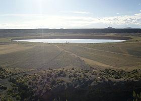
Jayu Quta (Aymara jayu salt, quta lake, "salt lake", also spelled Jayo Khota, Jayu Khota, Jayu Kkota) is a maar partially filled with water, in the Bolivian Altiplano, north of the Salar de Uyuni and east of the Salar de Coipasa. It is situated in the Oruro Department, Ladislao Cabrera Province, Salinas de Garci Mendoza Municipality, Villa Esperanza Canton. It was originally misidentified as a meteorite impact crater.
Map of Jayu Quta, Bolivia
A smaller maar, named Ñiq'i Quta ("mud lake", Nekhe Khota, Nekhe Kkota), is located southwest of Jayu Quta.
Volcanic activity of phreatomagmatic nature formed the maars, probably during the Holocene. During this activity, basalt-trachyandesite rocks were ejected, including xenoliths consisting of granite. These maars belong to a group of volcanic centres in the Altiplano. These centres mostly consist of lava flows of trachyandesitic to dacitic composition.
The maars appear to form a lineament with Ch'iyar Qullu. However, in terms of Pb isotope ratios and geochemistry the eruption products of the maars bear no resemblance to these at Chiyar Qullu.