Neha Patil (Editor)

Japan National Route 3

Updated on
Edit
Like
Comment
Share on FacebookTweet on TwitterShare on LinkedInShare on Reddit
Length
  
392.1 km

Japan National Route 3

South end:
  
National Route 10 in Kagoshima, Kagoshima

North end:
  
National Route 2 in Moji-ku, Kitakyushu

Highway system
  
National highways of Japan

Major cities
  
Fukuoka, Kumamoto, Kurume, Munakata, Yatsushiro, Satsumasendai, Yamaga, Tosu, Izumi

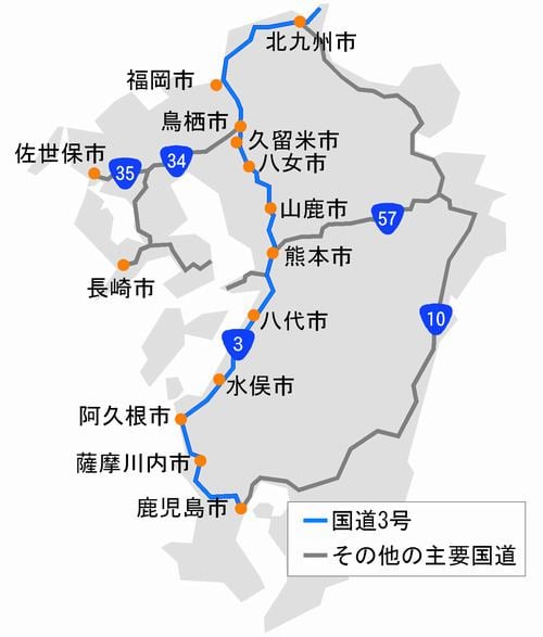
National Route 3 is a major highway on the island of Kyūshū in Japan. It connects the prefectural capital cities of Kagoshima (Kagoshima Prefecture, Kumamoto (Kumamoto Prefecture), and Fukuoka (Fukuoka Prefecture), passing through Kurume as well.

Contents

Map of Japan, %E5%9B%BD%E9%81%933%E5%8F%B7%E7%B7%9A

Its northern terminus is Moji-ku, Kitakyushu, where it meets National Route 2.

The total length of Route 3 is 392.1 km.

Route Data

  • Length: 392.1 km (243.7 mi)
  • Origin: Moji-ku, Kitakyūshū (originates at the terminus of Route 2)
  • Terminus: Kagoshima (ends at the terminus of Routes 10, 224, 225 and 226 and the origins of Route 58)
  • Major cities: Kitakyūshū, Fukuoka, Kurume, Kumamoto, Kagoshima
  • History

  • 1952-12-04 - First Class National Highway 3 (from Kitakyūshū to Kagoshima)
  • 1965-04-01 - General National Highway 3 (from Kitakyushu to Kagoshima)
  • Overlapping sections

  • From Moji-ku, Kitakyushu (Oimatsu-Park intersection) to Kokurakita-ku, Kitakyūshū (Mihagino intersection): Route 10
  • From Kurume to Yamaga (Chuo Street intersection): Route 325
  • From Yamaga (Nishiue-machi intersection) to Yamaga (Chuo Street intersection): Route 443
  • From Kita-ku, Kumamoto (Ueki-machi Mouno intersection) to Chūō-ku, Kumamoto (Suido-cho intersection): Route 208
  • From Minami-ku, Kumamoto (Chikami-machi intersection) to Uto (Matsuwara intersection): Route 57
  • From Chūō-ku, Kumamoto (Suido-cho intersection) to Uki (Matsubase-machi Kugu): Route 218
  • From Chūō-ku, Kumamoto (Suido-cho intersection) to Yatsushiro (Hagiwara-machi intersection): Route 219
  • From Kagoshima Oyamada-cho (Oyamada-cho intersection) to Kagoshima Shiroyama-cho (Central Park): Route 328
  • Municipalities passed through

  • Fukuoka Prefecture
  • Kitakyūshū - Mizumaki - Onga - Okagaki - Munakata - Fukutsu - Koga - Shingu - Fukuoka - Onojō - Dazaifu - Chikushino - (via Saga Prefecture) - Kurume - Hirokawa - Yame
  • Saga Prefecture
  • Kiyama - Tosu
  • Kumamoto Prefecture
  • Yamaga - Kumamoto - Uto - Uki - Hikawa - Yatsushiro - Ashikita - Tsunagi - Minamata
  • Kagoshima Prefecture
  • Izumi - Akune - Satsumasendai - Ichikikushikino - Hioki - Kagoshima
  • References

    Japan National Route 3 Wikipedia