Rahul Sharma (Editor)

Japan National Route 2

Updated on
Edit
Like
Comment
Share on FacebookTweet on TwitterShare on LinkedInShare on Reddit
Length
  
533.2 km

Japan National Route 2

East end:
  
National Route 1 / National Route 25 / National Route 176 in Umeda, Kita-ku, Osaka

West end:
  
National Route 3 / National Route 10 in Moji-ku, Kitakyushu

Highway system
  
National highways of Japan

Major cities
  
Kobe, Hiroshima, Himeji, Akashi, Okayama, Fukuyama

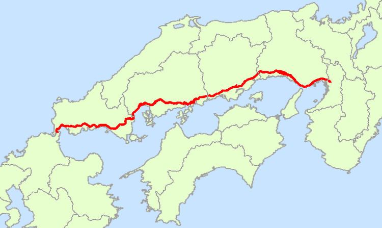
National Route 2 is a major highway on the islands of Honshū and Kyūshū in Japan. It follows the old Sanyōdo westward from the city of Osaka, Osaka Prefecture in the Kansai region to the city of Kitakyūshū in Fukuoka Prefecture, passing through the San'yō region en route. Between Hyōgo Prefecture and Yamaguchi Prefecture it parallels the Sanyō Expressway; it crosses the Kanmon Straits through the Kanmon Roadway Tunnel. Its total length is 533.2 km. At its Osaka terminus, it meets Route 1; at its western terminus, it links with Routes 3 and 10.

Contents

Map of Japan, %E5%9B%BD%E9%81%932%E5%8F%B7%E7%B7%9A

Route Data

  • Length: 533.2 km (331.4 mi)
  • Origin: Umeda, Kita-ku, Osaka (originates at the terminus of Routes 1, 25 and 176 and the origins of Routes 26, 163 and 165)
  • Terminus: Moji-ku, Kitakyushu (ends at the origins of Routes 3 and 10)
  • Major cities: Kobe, Himeji, Himeji, Okayama, Kurashiki, Fukuyama, Hiroshima, Iwakuni, Shimonoseki
  • History

  • 1952-12-04 - First Class National Highway 2 (from Osaka to Kitakyushu)
  • 1965-04-01 - General National Highway 2 (from Osaka to Kitakyushu)
  • Overlapping sections

  • From Nishinomiya (Fudabasuji intersection) to Kobe (San'nomiya-East intersection): Route 171
  • From Kobe (Higashi-Shiriike intersection) to Akashi (Kariguchi intersection): Route 28
  • From Kobe (Higashi-Shiriike intersection) to Akashi (Kokubo intersection): Route 250
  • From Himeji to Taishi Town (Taishi-Kamiota IC): Route 29
  • References

    Japan National Route 2 Wikipedia


    Similar Topics