
Last eruption 1966 | Age of rock Recent | |
 | ||
Similar Vatnafjöll, Esjufjöll, Theistareykjarbunga, Askja, Prestahnúkur | ||
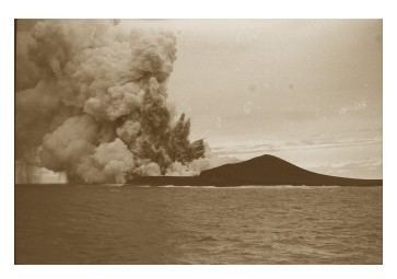
Jólnir was formerly a volcanic island south of Iceland. It was a former vent of Surtsey, along with Syrtlingur and Surtla. It emerged from the ocean as a result of active plate tectonics between December, 1965 and July, 1966. Oceanic erosion cyclically wore down the new lava as it formed, and the island sank below the surface several times.
Map of J%C3%B3lnir, Iceland
It was named for Jólnir, a Norse god (usually identified as a second name for Odin).
Jólnir's formation is closely linked to that of neighboring volcanic island, Surtsey, which emerged in 1963. Volcanic eruptions occurred in much of the surrounding water, but newly formed land was subject to erosion and many small islands washed away. By 1966, Jólnir had broken the surface and a volcanic cone of mafic tephra developed. The volcanic cone reached 210 feet (64 m) above sea level, but even this landmass eventually gave way to the eroding ocean waves.
After volcanic activity ceased on 8 August 1966, the Atlantic Ocean's waves rapidly eroded the volcanic island. Near the end September 1966, the island disappeared below the Atlantic Ocean's surface.