
Population 29,047 (Sep 2015) | Region Kantō Phone number 0299-23-1111 Local time Friday 5:51 AM | |
 | ||
Weather 3°C, Wind NW at 3 km/h, 79% Humidity Points of interest Gongenyama Park, Kasuminogo Park, Nihonmatsuji, Ou Shrine | ||
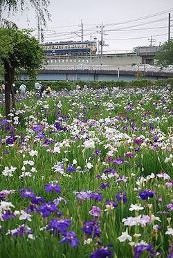
Itako (潮来市, Itako-shi) is a city located in Ibaraki Prefecture, in the northern Kantō region of Japan. As of September 2015, the city had an estimated population of 29,047 and a population density of 407 persons per km2. Its total area was 71.40 square kilometres (27.57 sq mi). It is known for its annual iris festival (the Itako Ayame Matsuri). Much of the city is within the borders of the Suigo-Tsukuba Quasi-National Park.
Contents
- Map of Itako Ibaraki Prefecture Japan
- Geography
- Surrounding municipalities
- History
- Education
- Railway
- Highway
- Local attractions
- Notable people from Itako
- References
Map of Itako, Ibaraki Prefecture, Japan
Geography
Itako is located in southern Ibaraki Prefecture, bordered by Chiba Prefecture to the south, and sandwiched between Lake Kasumigaura to the west and Lake Kitaura to the east. The Tone River also flows through the city, which has been noted since the Edo period for its network of canals. The city is approximately 80 kilometers north of Tokyo.
Surrounding municipalities
History
The town of Itako was established within Namegata District with the creation of the municipalities system on April 1, 1889. Itako annexed the neighboring villages of Tsuwa, Nobutaka and Ouhara on February 11, 1955. The city of Itako was established on April 1, 2001, from the merger of the former town of Itako, absorbing the town of Ushibori (both from Namegata District).
Education
Itako has six elementary schools, four middle schools, and one high school.