
Isle de jean charles louisiana documentary can t stop the water
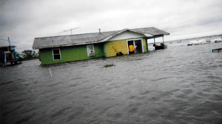
Isle de Jean Charles (known locally in Louisiana French as Isle à Jean Charles) is a narrow ridge of land situated in Terrebonne Parish, Louisiana. For over 170 years, it has been the historical homeland and burial ground of the state-recognized tribe of the Isle de Jean Charles Band of Biloxi-Chitimacha-Choctaw Indians. Residents of the Island have long been threatened by Louisiana's coastal erosion (coastal Louisiana loses a landmass the size of Manhattan every year). In 1955, Isle de Jean Charles consisted of over 22,000 acres and has since lost about 98% of its land due to saltwater intrusion, subsidence, and sea level rise. In January 2016, the state of Louisiana received substantial funding from the United States Department of Housing and Urban Development to fund the tribe's resettlement to safer ground.
Contents
- Isle de jean charles louisiana documentary can t stop the water
- Background
- Community Resettlement Efforts
- Representation in other media
- References
Background
In the 1830's, the tribe's ancestors moved to Isle de Jean Charles to escape consequences of the Indian Removal Act and the Trail of Tears. Traditionally, the tribe sustained itself through fishing and subsistence farming, both of which have become more difficult following environmental degradation and erosion of coastal areas.
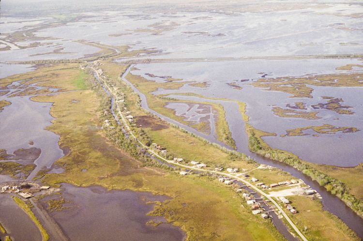
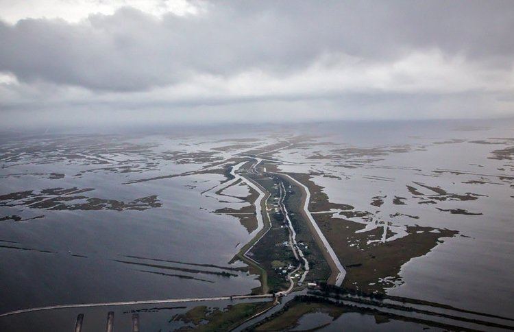
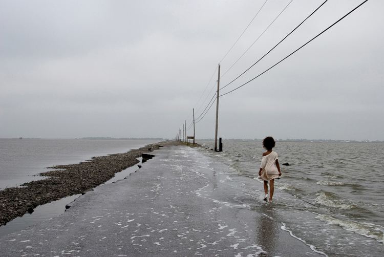
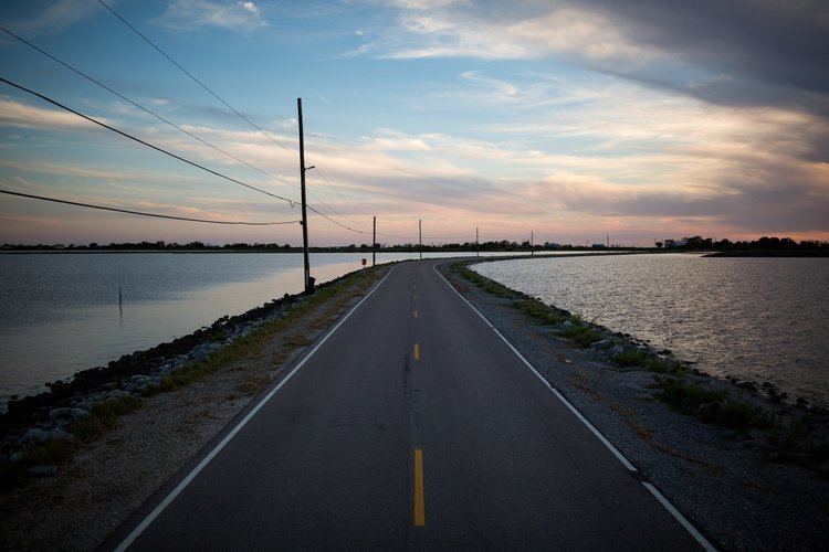
The island and its semi-abandoned village are located in eroding wetlands beyond the main levee systems of south Louisiana. The oil drilling, logging and the Army Corps of Engineers’ levee building on the Mississippi River have contributed to erosion of the wetlands, threatened also by sea level rise and intense hurricanes such as Katrina in 2005. In the 1950s, the island was 11 miles long and five miles wide. In 2016, it has been reduced to a quarter-mile wide and two miles long, and the causeway to it is also threatened. Today, only 25 families remain on the island, with many tribal members displaced.
Recent coastal restoration measures have not been able to salvage the island. The Army Corps of Engineers ended up leaving the Isle de Jean Charles out during levee projects which left the land even more vulnerable to natural disasters than the other surrounding areas.
Community Resettlement Efforts
Due to lack of government support for flood mitigation and land restoration, the Isle de Jean Charles Tribal Council decided they needed action and assistance for relocation of their whole community. Traditional Chief Albert Naquin and the Tribal Council have seen significant progress towards community resettlement throughout their nearly 20 years of working within the community, developing plans, building partnerships, and conducting outreach. While progress has been made, there have also been multiple setbacks which have stalled momentum.
In 2002, the US Army Corps of Engineers worked with the leadership of the Tribe to identify a nearby site where the community could rebuild. The USACE hired architects for the relocation proposal, with the idea of maintaining a cohesive community to be consistent with the tribe’s federal recognition process. But when it came time to vote, the majority of people from Isle de Jean Charles did not want to relocate. The USACE had counted non-residents and members of another tribe in the vote, causing confusion about the Isle de Jean Charles’ community goals. Some residents felt that the government wanted residents to relocate so the oil industry could have free range over the area without interference. Individuals within the tribe often grew up either experiencing or hearing about encounters with multinational oil and gas corporations and land developers taking their tribal and family land. The USACE representatives and others involved failed to recognize the sensitive nature of government representatives raising ideas about relocating a tribal community. Many within the community saw that USACE was lacking knowledge of local internal and intertribal politics, which resulted in counting people from another tribe in the vote to relocate.
The USACE stated that if the community could find an appropriate ridge to build on, they would reconsider including the community in the hurricane protection system. However, the USACE’s representatives did not listen to elders on the Island about where to take soil samples, maintaining instead that the cost-benefit ratio was not there to include the community in the levee system. The cost-benefit analysis used to make coastal restoration decisions did not account for the distribution of costs and benefits or important social and cultural factors, such as people’s identity, beliefs, traditions, livelihoods and sacred places. It did not include the social, psychological, and financial costs associated with moving fishing families inland, loss of local knowledge, and the mental stress of being removed from one’s home and traditional life.
In 2008, making another attempt at relocation, the Tribe encountered some issues while planning their move. Residents near the potential new home held concerns about property values decreasing that resembled the fears that led to white flight throughout the United States since the 1950s. As studies have shown, new residents do not decrease property values upon their arrival, but property values decrease as wealthier residents leave. As the restoration process became an object of commodification and racial tension throughout these setbacks, the residents became further displaced, estranged and alienated from the physical environment and denied the input of their local knowledge, which could be an invaluable contribution to the restoration process.
Since 2010 the Isle de Jean Charles community have worked with longtime partners at The Lowlander Center and a team of experts in hazard mitigation, climate adaptation, community planning, architecture, and other relevant fields, to develop their own plans for resettlement guided by local knowledge, the tribe's values, and with the hope of providing a model for other communities threatened by coastal erosion. Finally, on January 21, 2016, the State of Louisiana received $52 million from the Department of Housing and Urban Development to put towards the Isle de Jean Charles resettlement, as part of the National Disaster Resilience Competition (NDRC). The Isle de Jean Charles Resettlement Project was adopted by the state with minimal changes as a component in their application to the NDRC, giving the community renewed hope that the long overdue community-led and locally informed process of resettlement is finally underway.