
Country Capital | Area 906.00 km2 Population 1,151,868 | |
 | ||
Colleges and Universities Allama Iqbal Open University (Islamabad), International Islamic University - Islamabad (Islamabad), Quaid-i-Azam University (Islamabad), COMSATS Institute of Information Technology (Islamabad), National University of Sciences and Technology (Islamabad) Points of interest Rawal lake, Lok Virsa Museum, Faisal Mosque, Pir Sohawa, Islamabad Zoo | ||
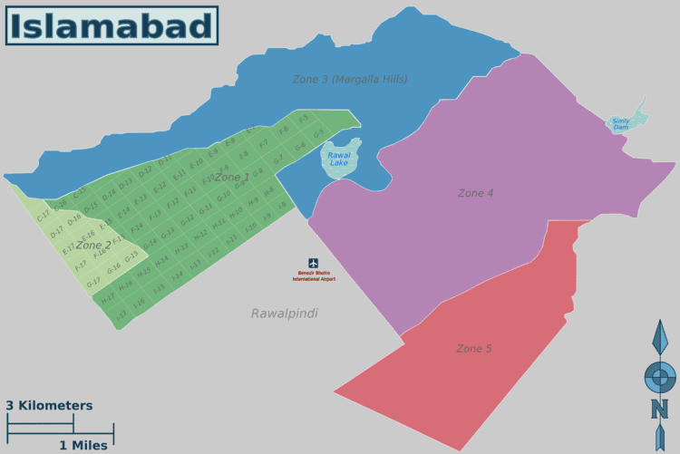
Map of Islamabad Capital Territory
The Islamabad Capital Territory (ICT) (Urdu: وفاقی دارالحکومت) is one of the two federal territories of Pakistan. It includes Islamabad, the capital city of Pakistan, and covers an area of 1,165.5 km2 (450 mi2) of which 906 km2 (349.8 mi2) is Islamabad proper. It is represented in the National Assembly by two constituencies, namely NA-48 and NA-49.
Contents
- Map of Islamabad Capital Territory
- The islamabad capital territory ict
- Jobs in islamabad capital territory pakistan
- History
- Introduction
- Government
- Union Councils
- Area and population
- Climate
- Civic administration
- Demographics
- IslamabadRawalpindi Metropolitan Area
- Economy
- Transport
- Education
- Public Sector UniversitiesDegree Awarding Institutes
- Private Sector UniversitiesDegree Awarding Institutes
- Sports
- References
The islamabad capital territory ict
Jobs in islamabad capital territory pakistan
History
In 1960, land was transferred from the Rawalpindi District of the Punjab province for the purpose of establishing Pakistan's new capital. According to the 1960 master plan, the ICT included the city of Rawalpindi, and was to be composed of the following parts:
However, the city of Rawalpindi was eventually excluded from the ICT on its creation in the 1980s. The remainder of the territory is now subdivided into five zones, with Zone I designated to house all residential, industrial and government institutions.
Punjab is located to the south of the ICT, and Khyber Pakhtunkhwa is located to the north west.
Introduction
Islamabad was designed and built to be a modern capital for Pakistan. It was established in 1960, on the orders of then President General Ayub Khan.
Islamabad nestles against the backdrop of the Margalla Hills at the northern end of Potohar Plateau. Its climate is healthy, relatively pollution free, plentiful in water resources and lush green. It is a modern and carefully planned residential city with wide roads and avenues, many public buildings and well-organised bazaars, markets, and shopping centres.
Government
Islamabad is situated between the provinces of Khyber Pakhtunkhwa and Punjab but Islamabad is not a part of any province. The federal Government of Pakistan controls it and is one of the two federal Territories of Pakistan (the other being FATA) which is directly governed by the Federal Government of Pakistan.
Union Councils
Islamabad Capital Territory comprises Islamabad city and surrounding rural areas. The rural area consists of 23 Union Councils, comprising some 133 villages, and city area has 27 Union Councils. The table below lists the 50 Union Councils, each Union Council is named after the main town.
Area and population
The city is divided into eight basic zone types: Administrative zone, Diplomatic Enclave zone, Residential Areas, Educational Sectors, Industrial Sectors, Commercial Areas, Rural Areas, Green Areas.
Each sector has its own shopping area, a green belt (which goes across the whole sector in a straight line) and public park. The population of the city is around 1,950,000 of which 66% is urban. It has an area of about 910 square kilometres. The city lies at latitudes 33° 49' north and longitudes 72° 24' east with altitudes ranging from 457 to 610 meters.
Climate
The climate of Islamabad has a humid subtropical climate (Köppen: Cwa), with five seasons: Winter (November–February), Spring (March and April), Summer (May and June), Rainy Monsoon (July and August) and Autumn (September and October). The hottest month is June, where average highs routinely exceed 38 °C (100.4 °F). Wettest month is July, with heavy rainfalls and evening thunderstorms with the possibility of cloudburst and flooding. Coolest month is January. Islamabad's micro-climate is regulated by three artificial reservoirs: Rawal, Simli, and Khanpur Dam. Last one is located on the Haro River near the town of Khanpur, about 40 kilometres (25 mi) from Islamabad. Simli Dam is 30 kilometres (19 mi) north of Islamabad. 220 acres (89 ha) of the city consists of Margalla Hills National Park. Loi Bher Forest is situated along the Islamabad Highway, covering an area of 1,087 acres (440 ha). Highest monthly rainfall of 743.3 millimetres (29.26 in) was recorded during July 1995. Winters generally feature dense fog in the mornings and sunny afternoons. In the city, temperatures stay mild, with snowfall over the higher elevations points on nearby hill stations, notably Murree and Nathia Gali. The temperatures range from 13 °C (55 °F) in January to 38 °C (100 °F) in June. The highest recorded temperature was 46.6 °C (115.9 °F) on 23 June 2005 while the lowest temperature was −6 °C (21.2 °F) on 17 January 1967. The city has "recorded" snowfall. On 23 July 2001, Islamabad received a record breaking 620 millimetres (24 in) of rainfall in just 10 hours. It was the heaviest rainfall in Islamabad in the past 100 years and the highest rainfall in 24 hours as well.
Civic administration
The main administrative authority of the city is Islamabad Capital Territory (ICT) Administration with some help from Capital Development Authority (CDA), which oversees the planning, development, construction, and administration of the city. Islamabad Capital Territory is divided into eight zones: Administrative Zone, Commercial District, Educational Sector, Industrial Sector, Diplomatic Enclave, Residential Areas, Rural Areas and Green Area.a.☃☃ Islamabad city is divided into five major zones: Zone I, Zone II, Zone III, Zone IV, and Zone V. Out of these, Zone IV is the largest in area All sectors of ghouri town (1, 2, 3, VIP, 5, 4-A, 4-B, 4-C, 5-A, 5-B and sector 7), located in this zone. Zone I consists mainly of all the developed residential sectors while Zone II consists of the under-developed residential sectors. Each residential sector is identified by a letter of the alphabet and a number, and covers an area of approximately 2 km× 2 km (mi☃☃km (☃☃☃☃mi☃☃× ☃☃☃☃mi). The sectors are lettered from A to I, and each sector is divided into four numbered sub-sectors.
Series A, B, and C are still underdeveloped. The D series has seven sectors (D-11 to D-17), of which only sector D-12 is completely developed. This series is located at the foot of Margalla Hills. The E Sectors are named from E-7 to E-17. Many foreigners and diplomatic personnel are housed in these sectors. In the revised Master Plan of the city, CDA has decided to develop a park on the pattern of Fatima Jinnah Park in sector E-14. Sectors E-8 and E-9 contain the campuses of Bahria University, Air University, and the National Defence University. The F and G series contains the most developed sectors. F series contains sectors F-5 to F-17; some sectors are still under-developed. F-5 is an important sector for the software industry in Islamabad, as the two software technology parks are located here. The entire F-9 sector is covered with Fatima Jinnah Park. The Centaurus complex will be one of the major landmarks of the F-8 sector. G sectors are numbered G-5 through G-17. Some important places include the Jinnah Convention Center and Serena Hotel in G-5, the Red Mosque in G-6, and the Pakistan Institute of Medical Sciences, the largest medical complex in the capital, located in G-8.
The H sectors are numbered H-8 through H-17. The H sectors are mostly dedicated to educational and health institutions. National University of Sciences and Technology covers a major portion of sector H-12. The I sectors are numbered from I-8 to I-18. With the exception of I-8, which is a well-developed residential area, these sectors are primarily part of the industrial zone. Currently two sub-sectors of I-9 and one sub-sector of I-10 are used as industrial areas. CDA is planning to set up Islamabad Railway Station in Sector I-18 and Industrial City in sector I-17. Zone III consists primarily of the Margalla Hills and Margalla Hills National Park. Rawal Lake is in this zone. Zone IV and V consist of Islamabad Park, and rural areas of the city. The Soan River flows into the city through Zone V.
Demographics
While urban Islamabad is home to people from all over Pakistan as well as expatriates, in the rural areas a number of Pothohari speaking tribal communities can still be recognized.
Islamabad/Rawalpindi Metropolitan Area
When the master plan for Islamabad was drawn up in 1960, Islamabad and Rawalpindi, along with the adjoining areas, was to be integrated to form a large metropolitan area called Islamabad/Rawalpindi Metropolitan Area. The area would consist of the developing Islamabad, the old colonial cantonment city of Rawalpindi, and Margalla Hills National Park, including surrounding rural areas. However, Islamabad city is part of the Islamabad Capital Territory, while Rawalpindi is part of Rawalpindi District, which is part of province of Punjab .
Initially, it was proposed that the three areas would be connected by four major highways: Murree Highway, Islamabad Highway, Soan Highway, and Capital Highway. However, to date only two highways have been constructed: Kashmir Highway (the former Murree Highway) and Islamabad Highway. Plans of constructing Margalla Avenue are also underway. Islamabad is the hub all the governmental activities while Rawalpindi is the centre of all industrial, commercial, and military activities. The two cities are considered sister cities and are highly interdependent.
Economy
Islamabad is a net contributor to the Pakistani economy, as whilst having only 0.8% of the country's population, it contributes 1% to the country's GDP. Islamabad Stock Exchange, founded in 1989, is Pakistan's third largest stock exchange after Karachi Stock Exchange and Lahore Stock Exchange. The exchange has 118 members with 104 corporate bodies and 18 individual members. The average daily turnover of the stock exchange is over 1 million shares. As of 2012, Islamabad LTU (Large Tax Unit) was responsible for Rs 371 billion in tax revenue, which amounts to 20% of all the revenue collected by Federal Board of Revenue.
Islamabad has seen an expansion in information and communications technology with the addition two Software Technology Parks, which house numerous national and foreign technological and information technology companies. The tech parks are located in Evacuee Trust Complex and Awami Markaz. Awami Markaz houses 36 IT companies while Evacuee Trust house 29 companies. Call centres for foreign companies have been targeted as another significant area of growth, with the government making efforts to reduce taxes by as much as 10% to encourage foreign investments in the information technology sector. Most of Pakistan's state-owned companies like PIA, PTV, PTCL, OGDCL, and Zarai Taraqiati Bank Ltd. are based in Islamabad. Headquarters of all major telecommunication operators such as PTCL, Mobilink, Telenor, Ufone, and China Mobile are located in Islamabad.
Transport
The Rawalpindi-Islamabad Metrobus is a 24 km (14.9 mi) bus rapid transit system that serves the twin cities of Rawalpindi and Islamabad in Pakistan. It uses dedicated bus lanes for all of its route covering 24 bus stations. Islamabad is well connected with other parts of the country through car rental services such as Alvi Transport Network and Pakistan Car Rentals.
All major cities and towns are accessible through regular trains and bus services running mostly from the neighbouring city of Rawalpindi. Lahore and Peshawar are linked to Islamabad through a network of motorways, which has significantly reduced travelling times between these cities. M-2 Motorway is 367 km (228 mi) long and connect Islamabad and Lahore. M-1 Motorway connects Islamabad with Peshawar and is 155 km (96 mi) long. Islamabad is linked to Rawalpindi through the Faizabad Interchange, which has a daily traffic volume of about 48,000 vehicles.
Education
Islamabad has the highest literacy rate of Pakistan at 95%. and also has some of Pakistan's major universities, including Quaid-i-Azam University, the International Islamic University, and the National University of Sciences and Technology and Pakistan Institute of Engineering and Applied Sciences
Private School Network Islamabad is working for private educational institutions. The president of PSN is Dr. Muhammad Afzal Babur from Bhara Kahu. PSN is divided into eight zones in Islamabad. In Tarlai Zone Chaudhary Faisal Ali from Faisal Academy Tarlai Kalan is Zonal General Sectary of PSN.
Quaid-e-Azam University has several faculties. The institute is located in a semi-hilly area, east of the Secretariat buildings and near the base of Margalla Hills. This Post-Graduate institute is spread over 1,705 acres (6.90 km2). The nucleus of the campus has been designed as an axial spine with a library as its center. Other universities include the following:
Public Sector Universities/Degree Awarding Institutes
Private Sector Universities/Degree Awarding Institutes
Sports
Islamabad United became the first ever team to win Pakistan Super League in 2016. And Now The Federal Team Is Participating In The Pakistan Cup The Team Is Under Captinacy of Misbah U Haq Former Captain Of Pakistan, The Islambad United Was Also Under Misbah