
Length 268 km Basin area 14,330 km² | Discharge 481 m³/s Source elevation 1,967 m | |
 | ||
- average 468 m/s (16,527 cu ft/s) Mouth Sea of Japan (also known as East Sea) | ||
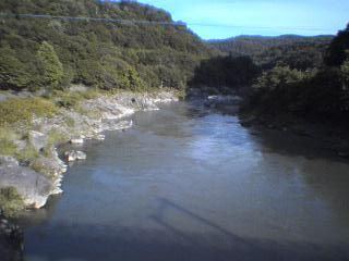
The Ishikari River (石狩川, Ishikari-gawa), at 268 kilometres (167 mi) long, is the third longest in Japan and the longest in Hokkaidō. The river drains an area of 14,330 square kilometres (5,530 sq mi), making it the second largest in Japan, with a total discharge of around 14.8 cubic kilometres (3.6 cu mi) per year.
Map of Ishikari River, Hokkaido Prefecture, Japan
It originates from Mount Ishikari in the Daisetsuzan Volcanic Group and flows through Asahikawa and Sapporo. Major tributaries of the river include the Chūbetsu, Uryū, Sorachi and Toyohira rivers. Until 40,000 years ago, it flowed into the Pacific Ocean near Tomakomai. Lava from the volcanic Shikotsu mountains dammed the river and moved its mouth to the Sea of Japan.
The name of the river is derived from the Ainu for "make(s) itself go round about something" (i-si-kari < kari meaning "(to be a) circle, round, loop; spin, turn, go around, go back and forth," si- "reflexive prefix, itself, oneself," and i- "it, something, an impersonal third person object marking prefix, middle voice inflection prefix), i.e. "winding (river)." As it suggests, the river once meandered in the Ishikari plain and was as long as the Shinano River, the longest river in Japan. Massive construction shortened the river by 100 kilometers and left many oxbow lakes (三日月湖, mikatsuki ko, lit. crescent moon lake) in the plain.