
- right Krtíš - average 21 m/s (742 cu ft/s) - min 3 m/s (106 cu ft/s) Basin area 5,151 km² | - max 70 m/s (2,472 cu ft/s) Length 232 km | |
 | ||
- location Lom nad Rimavicou, Slovakia | ||
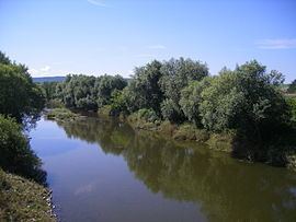
The Ipeľ (Slovak; [ˈipeʎ]) or Ipoly (Hungarian) (German: Eipel, archaic Slovak: Jupoľ ) is a 232-kilometre (144 mi) long river in Slovakia and Hungary, a tributary of the Danube River. Its source is in central Slovakia in the Slovak Ore Mountains. It flows south to the Hungarian border, and then southwest, west, and again south along the border until it flows into the Danube near Szob.
Contents
Map of Ipoly
The Ipeľ flows through or creates the border of the Banská Bystrica and Nitra regions in Slovakia, and Nógrád and Pest counties in Hungary.
Towns and villages
The following towns and villages are situated on the river, in downstream order:
References
Ipeľ Wikipedia(Text) CC BY-SA