
Existed: 1997 – present Length 67.9 km | Constructed 1997 | |
 | ||
Counties Durham County, North Carolina, Wake County, North Carolina | ||
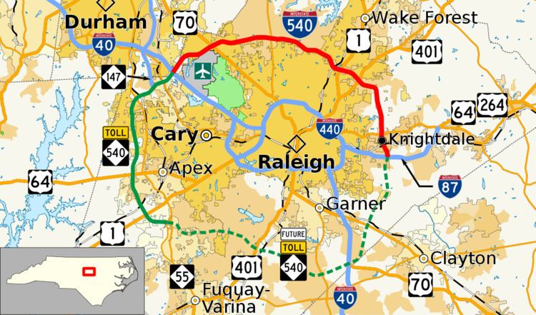
Interstate 540 (I-540) and North Carolina Highway 540 (NC 540) are part of a partially completed beltway around the city of Raleigh in the U.S. state of North Carolina forming the Raleigh Outer Loop. When complete, the route will completely encircle the city, meeting its parent route of Interstate 40 in two locations.
Contents
- Map of I 540 North Carolina USA
- Route description
- Interstate 540
- North Carolina Highway 540
- Tolls
- History
- Future
- Triangle Expressway Southeast Extension
- References
Map of I-540, North Carolina, USA
The initial phase of construction is designated Interstate 540, and was completed in January 2007. It runs from Interstate 40 near the RDU Airport to I-495/US 64/US 264 south of Knightdale. The original plan was for the entire route to be designated as part of the Interstate Highway System, possibly renumbering the route to I-640 when the beltway was complete. When it became financially unfeasible to construct the entire route with public funds, it was decided that the remaining portion of the route (approximately 2/3 of the total completed mileage) would be constructed as a toll road and designated as a NC State Route rather than an Interstate Route. The first section of NC 540 was opened in July 2007 extending westward from the western terminus of I-540. Further extensions have carried NC 540 around the western side of Wake County to its current southwestern terminus south of Apex. Future projects are planned to complete the southern leg from Apex to Garner and eastern leg, from Garner to Knightdale, under the same toll system. In particular, the portion south of Garner has been held up due to conflicting interests in choosing a path for the route. No clear timetable exists for completion of these two legs.
Route description
When completed, the beltway will total 70 miles (110 km) in length, surrounding the city of Raleigh and the towns of Apex, Cary, Garner, and Morrisville. The designation from I-540 and NC 540 happens at I-40, in Durham County, where I-540 goes east and NC 540 goes west.
The beltway is further broken down into four segments:
Interstate 540
I-540 is the designation for the northern part of the perimeter loop around Raleigh (not to be confused with the I-440 Beltline). Interstate 540 begins at Interstate 40 near the Raleigh-Durham International Airport. Interstate 540 continues northeast until it reaches Aviation Parkway. Interstate 540 has an interchange with Aviation Parkway and continues along the south side of the Brier Creek neighborhood. About a mile after Aviation Parkway I-540 has an interchange with Lumley Road before having another interchange with US 70. After the US 70 interchange the freeway turns a more easterly direction. Interstate 540 has another interchange with Leesville Road, about 3 miles from the US 70 interchange and then continues toward North Raleigh. As Interstate 540 curves around to its northernmost point it starts to parallel Strickland Road, which is further to the south. The road heads north of Wildwood Green Golf Course and then has interchange with NC 50. Further east I-540 has an interchange with Six Forks Road and then Falls of Neuse Road. After Falls of Neuse Road I-540 starts to turn a more southeastern direction. As it approaches US 1 (Capital Boulevard) I-540 crosses a railroad track owned by CSX on an elevated bridge. Interstate 540 has a somewhat combined interchange between US 1 (exit 16) and Triangle Town Boulevard (exit 17). As I-540 continues east it has an interchange with US 401 (Louisburg Road). Interstate 540 continues just south of the Wake Tech campus. I-540 crosses the Neuse River and then turns south towards Knightdale. I-540 immediately has an interchange with Buffaloe Road (exit 20). I-540 continues south paralleling both the Neuse River and Forestville Road. As I-540 enters Knightdale it has an interchange with US 64 Business. About 2 miles (3.2 km) after the US 64 Business interchange Interstate 540 has its western terminus at Interstate 495/US 64/US 264.
North Carolina Highway 540
NC 540 is the designation given to the Western Wake Freeway and future Southern and Eastern Wake Freeways. As of January 2013, the North Carolina state route traverses east–west from I-40, in Durham County to NC 55, in Holly Springs. Initially intended to be signed as an extension of the I-540 loop, the first section of the route bears mile markers and exit numbers for the complete Interstate loop, going from 66 to 69. In Mid-2012, this section of the beltway became part of the Triangle Expressway.
Tolls
No portion of I-540 is tolled. All of NC 540 is tolled except the short segment between I-40 and NC 54. Tolls are implemented by electronic toll collection (ETC) and are enforced by video cameras. Several gantries are located along the route and entrance/exit ramps, where they collect toll via the NC Quick Pass or other interoperable ETC systems. Those that do not participate in the ETC program will receive a bill in the mail and will have 30 days from date on bill before additional fees and civil penalties are applied.
History
Planning for the highway originally started in the early 1970s; by 1976, the "Northern Wake Expressway" was added to the planning map. In the mid-1980s, realizing that the growth in western Wake County may require more roads than planned, highway planners decided to expand the project as a new beltway around Raleigh. In 1992, construction began on the first 3-mile (4.8 km) section of the Northern Wake Expressway, connecting I-40 with US 70. On January 21, 1997, the freeway opened as Interstate 540.
In the following ten years, the now known Northern Wake Freeway (so not to be confused with the Triangle Expressway) made several extensions:
From 1999 to 2002, each additional section of the freeway was designated as Future 540, until it connected with US 1.
On July 14, 2007, a section of the loop from I-40 west to NC 54 and NC 55 was opened. However, the route is signed not as I-540 but as NC 540. Officials decided to change the designation in early July at the urging of the North Carolina Turnpike Authority (NCTA). Work on the western and southern portions of the beltway, if paid for by state funds, would possibly not open until 2030. At the request of several Wake County mayors, the NCTA in 2006 began studying the use of tolls to complete these portions of the Outer Loop.
The Authority concluded in early 2007 that it would be financially feasible to build the western section (along with an extended Durham Freeway, which combined would be called the "Triangle Expressway") using toll funds. The NCTA apparently never wanted an interstate designation for the Western Wake Parkway. To lessen motorist confusion about where I-540 ended, the route was truncated to the I-40 interchange. All I-540 signs that were put up along the unopened stretch between I-40 and NC 55 were taken down in early July 2007; the new section is now signed as NC 540. (In addition, I-540 as a completed loop would violate the Interstate numbering convention regarding three-digit routes, as spurs begin with an odd number and loops with an even number, and at one point, I-640 — the last remaining available number within the state, as I-240, I-440 and I-840 are already taken — was proposed for the loop.)
Work to build the Western Wake Freeway, which would be renamed the "Western Wake Parkway" under the toll proposal, began August 12, 2009, with the Triangle Parkway portion opening in December 2011, and Western Wake portion scheduled to open in two phases in 2012.
In October 2008, the authority was unable to issue bonds to fund the Western Wake Turnpike project as planned due to market conditions affecting municipal bonds such as those. On July 29, 2009, the Authority closed on a revised $1.01 billion bond plan, consisting of $270 million in toll revenue bonds, $353 million in Build America Bonds, and a $387 million loan from the U.S. Department of Transportation under the Transportation Infrastructure Finance and Innovation Act.
Groundbreaking was held on August 12, 2009 at the west end of Interstate 540. "A dozen dignitaries" used shovels painted gold as 150 watched.
After work began on Western Wake Parkway in 2009, engineering and environmental studies began a year later for the Southern and Eastern Wake Freeways, also known as the Triangle Expressway Southeast Extension. Construction would begin on 2014 and be completed by 2019; however, it was delayed on March 2011 by the enactment of North Carolina Session Law 2011-7 (N.C. S.L. 2011-7), which forbid NCDOT to consider a few alternative routes.
In 2010, NCDOT made an interchange improvement at I-540/I-40; adding another auxiliary lane from I-540 south to I-40 west, at a cost of $4.8 million.
The completed Triangle Parkway, the first section of the Triangle Expressway, with its connection to NC 540, opened on December 8, 2011, reestablishing exit 67. Collection of tolls began on January 3, 2012. On August 1, 2012, the first phase of the Western Wake Freeway opened, connecting NC 55 in Morrisville (exit 66) to US 64 in Apex. The next day tolling began on the previously open section from NC 54 to NC 55. The final phase of the tolled section of NC 540, from US 64 to NC 55 north of Holly Springs opened on December 20, 2012. Tolling for this section began January 2, 2013.
Future
NC DOT is planning to add two new interchanges on the Triangle Expressway. The first is at Old Holly Springs Apex Road, which is under construction and expected to open on November 29, 2016. The second is at Morrisville Parkway, which will be worked on along with the extension of Morrisville Parkway itself. Construction is expected to begin in 2017 and is expected to be open to traffic by 2018.
A plan approved by the Raleigh city council in November 2013 includes asking for tolls for the existing highway in order to widen it to eight lanes by 2035 or 2040. This would require both state and federal approval. As a temporary solution to increased traffic on the northern section, NCDOT was considering having some on-ramps use ramp meters, which would be the first ones in the state.
Triangle Expressway Southeast Extension
The Southern Wake Expressway would connect Holly Springs with Garner. The route for the southern leg known as the Orange Route, has been protected from development by NCDOT since the 1990s, but it would cross habitat for the endangered dwarf wedge mussel. The U.S. Fish and Wildlife Service asked for routes north of the Orange Route to be considered as a way to provide a shorter option, possibly minimizing impacts to natural resources. In September 2010, a new map showed several other routes, including the controversial Red Route, which many Garner-area residents protested in a December 2010 meeting; a total of 3,000 signatures on petitions opposed the route as well.
After two years, the General Assembly chose to permit studying the Red Corridor, which meant possible routes could once again be considered. Documents released September 9, 2013 changed the 30-mile project from two phases to a single project, with construction expected to begin in 2018 and be completed by 2022. Public meetings were scheduled in October 2013 for "Complete 540".
In April 2016, the NCDOT announced that Detailed Study Alternative 2 was selected as the preferred alternative for the project. The route goes from west to east and combines the proposed orange, green (southern portion), mint and green (northern portion) corridor segments.