
Existed: early 1980s – present Length 20.81 km | Counties: Pulaski | |
 | ||
Major cities | ||
Interstate 430 the purple heart trail
Interstate 430 (I-430) is a 12.93 miles (20.81 km) long Interstate highway in Pulaski County, Arkansas that bypasses the cities of Little Rock and North Little Rock. I-430 begins at an interchange southwest of Downtown Little Rock with I-30, U.S. Route 67 (U.S. 67) and U.S. 70 and travels north to cross the Arkansas River and end at I-40 and U.S. 65. The first plans for the freeway appeared in 1955.
Contents
- Interstate 430 the purple heart trail
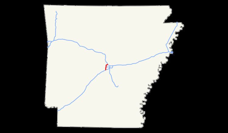
- Map of I 430 Little Rock AR USA
- interstate 30 west and interstate 430 north at little rock
- Route description
- History
- Exit list
- References
Map of I-430, Little Rock, AR, USA
interstate 30 west and interstate 430 north at little rock
Route description
Interstate 430 (I-430) starts its 12.93 miles (20.81 km) route at a trumpet interchange with I-30, U.S. Route 67 (U.S. 67) and U.S. 70. From the interchange, I-430 travels northwest and runs over Highway 338 (AR 338) before having a diamond interchange with AR 5. The freeway goes north to pass Remington College and intersect Colonel Glenn Road before curving eastward to intersect Shackleford Road and then turning back north. Immediately after going under Kanis Road, the highway has a cloverleaf interchange with I-630, at its western terminus. After I-630, the roadway goes past Immanuel Baptist Church and Breckenridge Village to intersect Rodney Parham Road near the Colony West Shopping Center and later AR 10. The AR 10 interchange was the final I-430 interchange before the freeway crossed the Arkansas River on the I-430 Bridge. After the bridge, the roadway passes Rosenbaum Lake and intersects with AR 100 before ending at a three-way interchange with I-40 and U.S. 65.
History
Early plans for the Interstate Highway System include a route along roughly the same alignment as the present Interstate 30 (I-30) through the Little Rock area, but are not detailed enough to show exactly how the cities would be served. Later, in 1955, a map of the Interstate Highway's plans shows a complete beltway around Little Rock, including present-day I-430, I-440 and Highway 440 (AR 440). When preliminary urban routes were laid out in 1955, the beltway was shortened to the current route of I-430.
Exit list
The entire highway is in Pulaski County.