
Existed: 1960 – present Length 40.35 km | Constructed 1960 | |
 | ||
Counties | ||
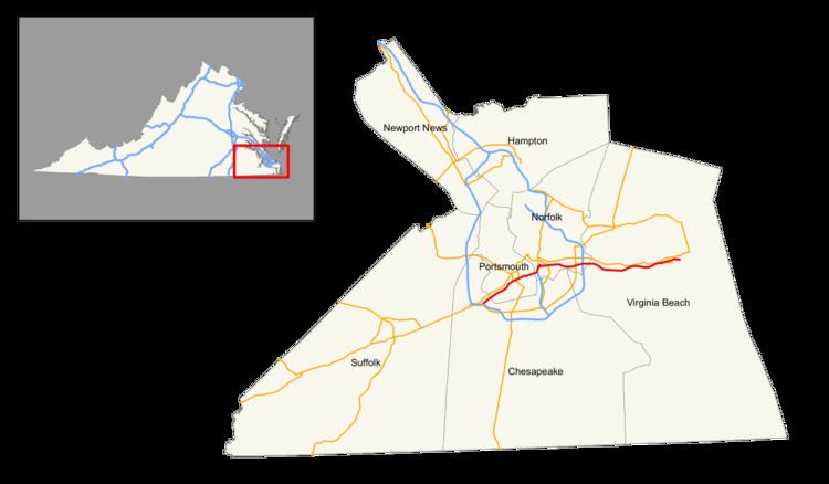
Interstate 264 (abbreviated I-264) is an Interstate Highway in the U.S. state of Virginia. It runs from a junction with Interstate 64 and Interstate 664 (Hampton Roads Beltway) near Bowers Hill in Chesapeake east into Portsmouth and through the Downtown Tunnel under the South Branch Elizabeth River into Norfolk. At the Interstate 464 interchange in the Berkley section of Norfolk, I-264 turns north, crossing the East Branch Elizabeth River into downtown Norfolk on the Berkley Bridge, one of a small number of drawbridges on the Interstate Highway System. I-264 then heads east through Norfolk, crossing Interstate 64 at the east side of the Hampton Roads Beltway, and into Virginia Beach, where it ends at Parks Avenue just short of the Atlantic Ocean. From this point, 21st and 22nd streets continue as a one-way pair with no route designation to U.S. Route 60 (Pacific Avenue).
Contents
Map of I-264, Virginia, USA
The original section of I-264, designated in the late 1950s, lies between the two I-64 junctions. The piece east to the Virginia Beach waterfront was built as the Virginia Beach-Norfolk Expressway (a toll road until 1995), and carried State Route 44 until I-264 was extended over it in 1999.
When I-64 was augmented in the 1990s with reversible HOV lanes, I-264 towards Virginia Beach (then SR 44) was designated as the eastern terminus of the reversible lanes and one of the few direct exits from/entrances to the HOV lanes.
I-264 is a part of the National Highway System for its entire length. A toll for use of the Downtown Tunnel began February 1, 2014. Tolls are collected electronically and (as of 2015) set at $1.25 during peak hours and $1.00 during off-peak hours for E-ZPass users.
Route description
I-264 begins at a full Y interchange in the Bowers Hill area of the city of Chesapeake. This interchange also serves as the eastern terminus of I-64 and the southern terminus of I-664, which together comprise the Hampton Roads Beltway. I-664 is used to access US 13, US 58, and US 460, which all head west toward Suffolk. I-264 heads northeast as a four-lane freeway into the city of Portsmouth, where the highway meets Greenwood Drive at a cloverleaf interchange and SR 239 (Victory Boulevard) at a diamond interchange where the Interstate expands to six lanes. The Interstate highway begins an unsigned concurrency with US 460 Alternate at a partial interchange with SR 337 (Portsmouth Boulevard), which allows access between I-264 toward Chesapeake and SR 337 toward Norfolk and between SR 337 toward Chesapeake and I-264 toward Norfolk. I-264 continues east through a partial cloverleaf interchange with US 17 (Frederick Boulevard). A partial junction with Des Moines Avenue allowed access to and from the west, but since November 2013, access to Des Moines Avenue has been permanently closed for construction of the Martin Luther King Freeway interchange. (As of January 2014, traffic can still reach westbound I-264 from this junction, but that is expected to close later in the year.)
I-264's final interchange in Portsmouth provides access to SR 141 (Effingham Street) in downtown Portsmouth; westbound I-264 traffic has ramps to and from Bart Street. This interchange, which also serves the Norfolk Naval Shipyard, is where the Interstate reduces to four lanes and descends into the Downtown Tunnel under the Southern Branch Elizabeth River. I-264 surfaces in the city of Norfolk and immediately has an interchange with I-464, which heads south toward Chesapeake. The I-464 interchange also provides access to Berkley Avenue in the Berkley section of Norfolk. I-264 curves north as an eight-lane highway that crosses the Eastern Branch Elizabeth River on a drawbridge. At the north end of the drawbridge, the two directions of the Interstate temporarily split and have a series of ramps to Waterside Drive, St. Paul's Boulevard, City Hall Avenue, and Tidewater Drive at the eastern end of Downtown Norfolk. These streets provide access to Harbor Park, a baseball stadium that is home to the Norfolk Tides, and a new Amtrak terminal for service to routes along the northern I-95 corridor.
I-264 continues east as an eight-lane freeway between the Eastern Branch Elizabeth River to the south and the Tide Light Rail tracks to the north. The Interstate has an interchange with US 460, SR 166, and SR 168, which head northwest toward downtown Norfolk as Brambleton Avenue and south across the river as Campostella Road. There is no access between Brambleton Avenue and I-264 toward downtown. East of US 460, the freeway passes to the south of Norfolk State University and has a diamond interchange with SR 405 (Ballentine Boulevard). I-264 crosses Broad Creek and gains collector-distributor lanes for the next three, closely spaced interchanges. These junctions include a cloverleaf interchange with US 13 (Military Highway), a cloverleaf interchange with several flyover ramps at I-64 (Hampton Roads Beltway), and a partial cloverleaf interchange with SR 403 (Newtown Road). The middle carriageway of I-64 headed north, which has two HOV lanes, merges with both directions of I-264 heading east. I-264 enters the city of Virginia Beach at the Newtown Road interchange.
I-264 continues east as the Virginia Beach Expressway, an eight-lane freeway where the innermost lane in each direction is an HOV lane. The first two interchanges in Virginia Beach, a partial cloverleaf junction with SR 190 (Witchduck Road) and a cloverleaf interchange with SR 225 (Independence Boulevard), serve the Pembroke Area, which is the central business district of the city. Independence Boulevard also leads southeast toward Mount Trashmore Park, a reused landfill that is visible from the freeway, and further on towards the Virginia Beach Amphitheater and eventually the city's government center at Princess Anne. I-264 next has a partial cloverleaf interchange with Rosemont Road and a cloverleaf interchange with Lynnhaven Parkway, which leads to the Lynnhaven Mall. The Interstate crosses London Bridge Creek, a tributary of the Lynnhaven River, ahead of a partial interchange with London Bridge Road (also providing access to Great Neck Road) and then a crossover interchange that connects the freeway toward Norfolk with US 58 (Laskin Road) and US 58 Business (Virginia Beach Boulevard) toward the oceanfront. I-264's HOV lanes end and the highway reduces to six lanes ahead of the interchange with First Colonial Road north of Oceana Naval Air Station. The Interstate crosses Great Neck Creek and has its final interchange, a partial interchange with Bird Neck Road that provides an alternative route to the oceanfront, before approaching its eastern terminus. I-264's eastern terminus is at Parks Avenue just north of the Virginia Beach Convention Center. The carriageways continue east as a one-way pair, 21st Street eastbound and 22nd Street westbound, east to US 60 (Pacific Avenue) and Atlantic Avenue at the Virginia Beach Oceanfront.
Original I-264
Originally, in 1960, I-264 was planned as an Interstate highway through downtown Norfolk, Virginia.
Virginia Beach Expressway
The Virginia Beach Expressway (also known as the Virginia Beach-Norfolk Expressway) was a 12-mile (19.3 km) limited access highway built to Interstate Highway standards extending between the independent cities of Norfolk and Virginia Beach, Virginia. Until 1999, it was signed as State Route 44.
Built and funded with toll revenue bonds, it opened on December 1, 1967 as SR 44. The Expressway ran from an interchange with Interstate 64 and Interstate 264 in Norfolk almost due east to the oceanfront area of Virginia Beach. The original road had 4 lanes (2 each way). It was widened to six lanes in the 1980s, and to eight lanes in the early 1990s.
A two-tier toll structure existed, with lower tolls for those who passed the main toll barrier between Rosemont Road and Independence Boulevard. Technical errors were common; alarms installed to alert police of a non-paying motorist would often be activated by the machine's failure to detect the insertion of the proper toll.
On June 1, 1995, the bonds were retired, and tolls and toll booths were removed in 1996. In July 1999, the former Virginia Beach Expressway was renumbered to I-264, effectively creating an eastward continuation of the original I-264, which ran through the downtown areas of Portsmouth and Norfolk and ended at I-64 (where the Expressway began). This is now the point where I-264 intersects and crosses the I-64 portion of the Hampton Roads Beltway near Military Circle in Norfolk.