
Existed: 1956 – present Length 36.9 km | Northeast end: I-71 in Glenview Manor Constructed 1956 | |
 | ||
History: Construction completed in 1974 | ||
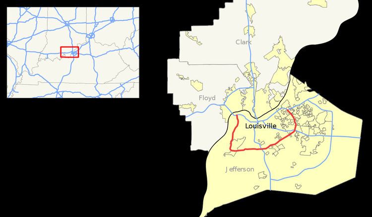
Interstate 264 is a loop around the south side of the city of Louisville, Kentucky. A child route of I-64, it is signed as the Georgia Davis Powers Expressway for its first eight miles from its western terminus at I-64/US-150 to US-31W/US-60; and as the Henry Watterson Expressway for the remainder of its length from US-31W/US-60 to its northeastern terminus at I-71. It is 22.93 miles (36.90 km) in length, and runs an open circle around central Louisville, Kentucky. The highway begins four miles (6 km) west of downtown at I-64 just east of the Sherman Minton Bridge which links Southern Indiana with Kentucky as it crosses the Ohio River. The interstate ends approximately six miles northeast of downtown Louisville, where it connects to I-71.
Contents
- Map of I 264 Louisville KY USA
- History
- Watterson Expressway Reconstruction 19851995
- Shawnee Expressway Reconstruction 20032004
- Westport Road interchange 2008 2010
- Exit list
- References
Map of I-264, Louisville, KY, USA
Louisville is one of few U.S. cities with two Interstate Highways serving as inner and outer beltways. I-264 is Louisville's inner beltway (in conjunction with I-64 and I-71) and the later constructed I-265, the Gene Snyder Freeway, is Louisville's outer beltway. I-264 is currently used as the primary detour route when Interstate 64 is closed through Downtown Louisville. This may change for through traffic in late 2016 with the completion of the East End Bridge, which will connect the currently separate segments of I-265 in Kentucky and Indiana.
In discussions about the city, Interstate 264 is often used as a rough line dividing the older areas of Louisville from its suburbs.
History
In 1948, a bypass was built between Shelbyville Road and U.S. Route 31W (Dixie Highway) in Louisville, as a relocation of US 60. It was incorporated into the Interstate Highway System in 1956. The highway was completed in 1974, and in 1952 the road from Dixie Highway east to I-71 was named after the journalist and editor Henry Watterson. The designation US 60 was dropped in 1984 when the original surface roads through Louisville were restored to their original US 60 designation.
The western segment from Dixie Highway to I-64 northwest of downtown Louisville was opened in segments from 1970 to August 1974. This stretch of I-264 was originally named, and is still often referred to as, the Shawnee Expressway. On April 1, 2010, the Kentucky General Assembly designated this portion to be renamed as the Georgia Davis Powers Expressway
Watterson Expressway Reconstruction (1985–1995)
The Watterson Expressway underwent a major reconstruction effort that began in 1985. The vintage freeway had outlived its useful purpose and had numerous characteristics that defined it as a blight on Louisville: deteriorating overpasses, buckling pavement, deficient and too closely spaced interchanges, and rampant congestion. Dozens of bridges were reconstructed and widened, and the majority of the interchanges were redesigned and rebuilt from the ground up from Dixie Highway east to Shelbyville Road. The entire highway reconstruction project was completed in 1995.
A typical deficient interchange along I-264 was the I-65, Kentucky Exposition Center and Louisville International Airport exit. Before the reconstruction, two cloverleafs with no collector and distributor lanes existed and posed serious weaving issues. The interchange today has been rebuilt and features numerous flyovers and collector and distributor lanes, making it safer, though not necessarily easier to navigate.
Shawnee Expressway Reconstruction (2003–2004)
The segment of I-264 from Dixie Highway to the northwest I-64 interchange opened in segments from 1970 to August 1974 and received no more than emergency or spot patching. After several years of planning, in early 2003, the Kentucky Transportation Cabinet began a rehabilitation project on this segment of Interstate Highway stretching from the Dixie Highway interchange northwest to just east of Bank Street.
A concrete surface several inches thick was constructed on the mainline and access ramps, a new median barrier was formed, new lighting fixtures were installed, 37 bridges were rehabilitated, and 380 new roadway signage was posted and all guardrails were replaced as part of the 7.6-mile (12.2 km) project. In addition, the segment from River Park Drive to I-64, which was only two lanes, was widened to three lanes. No major ramp or interchange modifications were needed. The highway reconstruction project cost approximately $66 million and required 18 months of labor.
About 70,000 vehicles a day use the portion of Interstate 264 near Dixie Highway and about 40,000 daily use the segment near its western terminus with I-64.
Westport Road interchange (2008-2010)
Although the Kentucky General Assembly considered plans for an interchange with Westport Road (Kentucky Route 1447) as early as 1992, work did not begin until October 2008 and was completed in May 2010.
Exit list
The entire route is in Louisville, Jefferson County.