
Existed: c. 1970 – present Length 5.6 km | Constructed 1970 | |
 | ||
North end: I‑64 / I‑95 in Richmond Counties Richmond, Henrico County, Virginia | ||
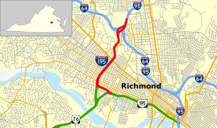
Interstate 195 (I-195) is an Interstate Highway in the U.S. state of Virginia. Known as the Beltline Expressway, the highway runs 3.50 miles (5.63 km) from Virginia State Route 195 (SR 195), a toll road that continues south into Downtown Richmond, north to I-64 and I-95 on the northern edge of Richmond. I-195 passes through the West End of Richmond and connects I-64 and I-95 with U.S. Route 33 and US 250, which follow Broad Street, and with SR 76, a toll road that links Richmond with the Southside of the metropolitan area.
Contents
Map of I-195, Richmond, VA, USA
Route description
I-195 begins as a continuation of SR 195 (Downtown Expressway), a toll road that connects I-195 with I-95 in Downtown Richmond. The transition between the Interstate and the state-numbered highway occurs just east of the McCloy Street overpass south of the Carytown district of Richmond. The four-lane freeway gains a pair of lanes just west of the transition where there is a southbound exit ramp for Rosewood Avenue, which leads to City Stadium, and a northbound entrance ramp from Idlewood Avenue. Northbound I-195 has an exit for SR 147 (Cary Street) and Floyd Avenue, while a ramp from SR 147 joins the southbound Interstate as the highway curves north on a pair of two-lane flyover ramps to join the six lanes of SR 76 (Powhite Parkway) that join the Interstate at that toll road's northern terminus.
I-195 continues northeast as a six-lane freeway with its median occupied by CSX's two-track North End Subdivision, which also serves Amtrak. The southbound Interstate has an exit ramp to Hamilton Street, which parallels the Interstate to the west, to serve SR 147 and Grove Avenue. A short distance to the north, northbound I-195 has exit and entrance ramps to and from Thompson Street, which parallels the Interstate to the east, to access SR 6 (Patterson Avenue) and Grove Avenue. North of Monument Avenue, from which the southbound direction receives a ramp, I-195 has a multi-part interchange with Broad Street, which carries US 33 and US 250. The southbound freeway receives a ramp from Hamilton Street and the northbound freeway has an exit ramp to Clay Street north of the Broad Street overpass. After the overpass, northbound I-195 crosses over the North End Subdivision and both directions pass under Hamilton Street, with which the freeway has a half-diamond interchange that allows access to US 33 and US 250 from the north.
I-195 passes through an industrial area in which the highway crosses over SR 197 (Westwood Avenue) and a rail yard of CSX's RF&P Subdivision just north of its wye junction with the North End Subdivision. While on the viaduct, the Interstate briefly enters Henrico County. North of the S-curved viaduct, I-195 has a three-quarter diamond interchange with the western end of Laburnum Avenue, which provides access to SR 197. The interchange's north-facing ramp is from eastbound I-64 within the Bryan Park Interchange, a three-level stack interchange with multiple flyover ramps where I-195 reaches its northern terminus at I-64 and I-95 south of Bryan Park at the northernmost point in the city of Richmond. Ramps to southbound I-195 converge and ramps from northbound I-195 diverge for westbound I-64 toward Charlottesville, northbound I-95 toward Washington, and eastbound I-64 and southbound I-95 (Richmond–Petersburg Turnpike) toward Downtown Richmond, where the Interstates diverge toward Norfolk and Petersburg, respectively.