
Nearest town or city Marion Bay Website Innes National Park Phone +61 8 8854 3200 | Visitation 200,000 (in 2003) Area 94.15 km² Established 1970 | |
 | ||
Managing authorities See also Protected areas of South Australia Address Inneston SA 5577, Australia Hours Open today · Open 24 hoursAdelaide Cup Day might affect these hoursMonday(Adelaide Cup Day)Open 24 hoursHours might differTuesdayOpen 24 hoursWednesdayOpen 24 hoursThursdayOpen 24 hoursFridayOpen 24 hoursSaturdayOpen 24 hoursSundayOpen 24 hours Similar Pondalowie Bay, Lincoln National Park, Mount Remarkable National, Deep Creek Conserva, Leven Beach Conserva | ||
Innes national park south australia
Innes National Park is a protected area on the southwest tip of Yorke Peninsula in South Australia, 300 kilometres (190 mi) west of the Adelaide city centre. Known as Innes by many, the national park is a popular destination for camping, bushwalking, fishing, surfing and scuba diving.
Contents
- Innes national park south australia
- Location
- Extent
- Physical landscape
- Road system
- Protected area designation
- Flora
- Fauna
- History
- Prior use of the land
- Camping
- Indoors accommodation
- Walking
- Surfing
- Statutory
- Non statutory arrangements
- Natural heritage
- Aboriginal heritage
- Mining
- Shipwrecks
- References
Location
Innes National Park is located on the southern western extremity of Yorke Peninsula in South Australia about 300 kilometres (190 mi) by road from the Adelaide city centre. It is located within the locality officially known as Inneston.
Extent
The national park occupies most of the land on the south-western tip of Yorke Peninsula south west of a line running from Willyama Bay on the south coast of the peninsula near Marion Bay to Gym Beach on the west coast of the peninsula and the following four islands immediately adjoining the coastline (from east to west): Chinamans Hat Island, Middle Island and South Island west of Pondalowie Bay, and Royston Island immediately west of Royston Head.
Within the above area, land excluded from the national park includes the following saline lakes which were associated with gypsum mining at the time of proclamation of the national park - Marion Lake, Snow Lake and Spider Lake.
As of 2014, the national park included the following "no access" areas (from east to west) - a section of coastline between Cape Spencer and Ethel Beach, South and Middle Islands at the entrance to Pondalowie Bay, Royston Island, the coastline between Royston Head and Dolphin Beach, and the coastline between Browns Beach and Gym Beach.
Physical landscape
The coastline extending from Willyama Bay to Cape Spencer consists of a number of bays such as Cable Bay and Stenhouse Bay with some prominent headlands such as Rhino Head and a line of cliffs between Cable Bay and Stenhouse Bay. From Cape Spencer to West Cape, an unbroken line of cliffs ranging in height between 37 metres (121 ft) and 79 metres (259 ft) with some sandy beaches at their feet make up the south west coast of Yorke Peninsula. From West Cape to Pondalowie Bay, the cliff line is of a relatively lower height. From the south end of Pondalowie Bay to Gym Beach, areas of sand dunes dominate the shoreline and the land immediately adjoining it with the exception of Royston Head and the cliff line extending eastward to Dolphin Beach. The land between the national park’s boundary and the road system is dominated in part by a network of saline lakes.
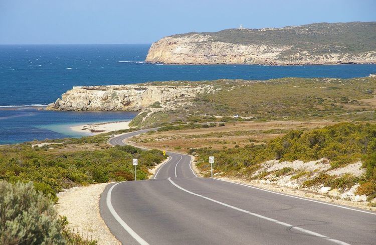
Road system
The national park is serviced by a road connected to the western end of the Yorke Highway which passes through Marion Bay. The road which starts at Stenhouse Bay follows the coastline as a sealed road passing Chinamans Hat Island, Cable Bay and the turn-offs to Cape Spencer, Ethel Beach, West Cape and two camping grounds at Pondalowie Bay. The road concludes as a sealed road at the turn-off to the Pondalowie Surf Break Carpark. It continues as an unsealed road, passing turn-offs to Dolphin Beach and Shell Beach, to terminate at Browns Beach in the north west of the national park. Gym Beach in the extreme north west, while being accessible via the national park’s walking trail system can only reached via vehicle from the Marion Bay Road which is located to the east of the national park’s boundary.
Protected area designation
The national park is classified as an IUCN category II protected area.
Flora
As of 2003, 333 species of native plants had been recorded in Innes National Park of which 115 species were of conservation significance including 24 scheduled in the South Australian National Parks and Wildlife Act 1972 and the following four species listed in the Australian Environment Protection and Biodiversity Conservation Act 1999: annual candles, winter spider-orchid, bead samphire and splendid bush-pea.
Fauna
Native mammals found within the national park as of 2003 included New Zealand fur seal, western pygmy possum, Gould’s wattle bat, chocolate wattled bat, common dolphin, southern right whale, western grey kangaroo, Australian sea lion, short-beaked echidna and bottlenose dolphin.
Birds found within the national park as of 2003 included 111 species of native bird of which 13 species were scheduled in Australian and state legislation. The following 13 species were listed in the National Parks and Wildlife Act 1972 either as being vulnerable or rare species - chestnut quail-thrush, eastern reef egret, fairy tern, hooded plover, little tern, malleefowl, osprey, painted button-quail, peregrine falcon, rock parrot, shy heathwren, western whipbird and white-bellied sea-eagle while the malleefowl was also recognised nationally as a vulnerable species under the Environment Protection and Biodiversity Conservation Act 1999.
Reptiles found within the national park as of 2003 included marbled gecko, mallee snake-eye, painted dragon, barking gecko, yellow-faced whipsnake, black tiger snake, eastern stone gecko, eastern bearded dragon, bull skink, eastern brown snake, four-toed earless skink, peninsula brown snake, southern four-toed slider, common scaly-foot, dwarf skink, western bluetongue, Adelaide snake-eye, sleepy lizard and prickly dragon.
Introduced animals found within the national park as of 2003 included rock dove, cat, rabbit, house mouse, house sparrow, black rat, common starling and fox.
History
Innes National Park was declared in 1970 "to conserve important habitat for the western whipbird, the mallee fowl and to protect a number of heritage buildings at Inneston." Land was added to the national park in 1977, 1984 and 1993 in order to deal with increased recreational use.
Prior use of the land
The Narungga people occupied the Yorke Peninsula for thousands of years. They consisted of four clans, the Kurnara of the north, the Windera of the east, the Wari of the West and the Dilpa of the south.
European colonisation of the area began in 1846 with sheep grazing near Cape Spencer. Crops were grown on a small scale in the 19th and early 20th century. Innes National Park was named after William Innes, who discovered commercial quantities of gypsum in the early 1900s and founded the mining town of Inneston in 1913, which had a population of around 500 at its peak. Gypsum was mined until 1930 when the Great Depression made it uneconomical, and in 1970 the town and surrounding land was sold to the South Australian government, creating Innes National Park. Some gypsum mining still continues at nearby Marion Bay.
Some of the buildings at Inneston have been restored and are available as basic hire accommodation.
Camping
Camping grounds are available at the following locations (from east to west) - Stenhouse Bay, Cable Bay, Pondalowie Bay (three sites including one for caravans and trailers), Shell Beach, Browns Beach and Gym Beach.
Indoors accommodation
Indoor accommodation is available at three locations - a number of restored buildings at Inneston, the Stenhouse Bay hall and a cottage at Shell Beach.
Walking
A system of trails allows visitors to the national park to enjoy views of the coastline and adjoining waters and to observe flora and fauna including species such as southern right whales and dolphins and features such as lighthouses and heritage sites. As of 2014, there are three major walking trails - the Thomson Pfitzner Plaster Trail Hike that connects Stenhouse Bay and Inneston, the Royston Head Hike from Dolphin Beach to Royston Head and the Gym Beach Hike which connects Browns Beach and Gym Beach. A number of minor trails connect the road system to locations such as Cape Spencer, Ethel Beach, West Cape and Pondalowie Bay.
Surfing
The main surf break at Pondalowie is a popular quality wave. It consists of a combination left and right peak that breaks over a reef and sand bottom. The left is good up to about 4 feet. The right starts to become good from between 3 and 8 feet plus. A second smaller right hand reef break known as 'Richards Reef' is located 250 metres further north along the beach. It was named in honour of Mr Richard Thomas a long time local surfer and resident of the area. Not far from Stenhouse Bay is a break known as 'Chinamans'. This is a powerful and hollow left hand reef break which breaks in shallow water and washes over a rock shelf. It is a high quality wave that is suitable only for skilled surfers and caution should be used when surfing here.
Statutory
The waters adjoining the coastline of the national park including the four islands are within a Habitat Protection Zone in the Southern Spencer Gulf Marine Park.
Non-statutory arrangements
The national park is within the extent of an Important Bird Area known as the Southern Yorke Peninsula Important Bird Area, identified as such by BirdLife International because it supports populations of malleefowl as well as of other threatened bird species including the western whipbird.
Natural heritage
The following three lakes which support a population of stromatolites are listed on the South Australian Heritage Register maintained by the South Australian Government - Deep Lake, Inneston Lake and Marion Lake.
Aboriginal heritage
As of 2003, 21 sites of significance to the Narungga people had been identified. These consisted of "burial sites" and a broad classification known as "archaeological sites".
Mining
The following two sites at Inneston and Stenhouse Bay associated with the mining of gypsum are listed on the South Australian Heritage Register - the "Inneston Gypsum Complex" and the Stenhouse Bay Jetty.
Shipwrecks
At least four shipwrecks which are located within the national park or immediately adjoining its coastal boundary are protected under Australian and state historic shipwrecks legislation.
SS Marion which run aground to the immediate east of Chinamans Hat Island during 1862 is protected under the Australian Historic Shipwrecks Act 1976.
Ethel which run aground on the coastline between West Cape and Cape Spencer on a beach now known as Ethel Beach during 1904 is protected under the South Australian Historic Shipwrecks Act 1981.
SS Ferret which run aground in 1920 on what is now Ethel Beach is protected under the Historic Shipwrecks Act 1976.
Hougomont which was scuttled in 1932 to form a breakwater lies close to the coastline near Stenhouse Bay is protected under the Historic Shipwrecks Act 1981.