
Opening date 2001 Height 45 m | Type of dam Gravity, masonry Length 539 m (1,768 ft) Construction began 1978 | |
 | ||
Official name Upper Indravati Power Station Similar Mandira Dam, Kolkewadi Dam, Jalaput Dam, Mahanadi Bridge - Boudh, Lankeswari Temple | ||
Indravati dam
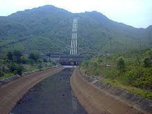
Indravati Dam is a gravity dam on the Indravati River, about 90 km from Bhawanipatna in the state of Odisha in India. It is connected to the main Indravati reservoir via 4.32 km long and 7 m dia head race tunnel designed for a discharge capacity of 210 cumecs and terminating in a surge shaft. Currently it is the largest power producing dam in eastern India with a capacity of 600 MW.
Contents
Map of Indravati Dam, Nagi, Odisha 766026
The Upper Indravati Project envisages diversion of water of the Indravati river in its upper reaches into the Mahanadi river basin for power generation and irrigation. In addition to the power house, the project involved construction of 4 dams across the Indravati and its tributaries, 8 dykes and two inter-linking channels to form a single reservoir with a live capacity of 1,435.5 Million m3 and a barrage across Hati river in Mahanadi river basin.