
Length 147.2 km | Constructed 28 March 1932 | |
 | ||
Existed: March 28, 1932 – present Counties Carroll County, Indiana, Cass County, Indiana, Miami County, Indiana, Wells County, Indiana, Adams County, Indiana | ||
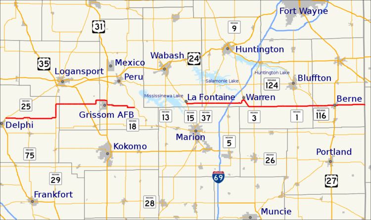
Indiana State Road 218 exists in two different sections in the central part of the U.S. state of Indiana, on either side of Mississinewa Lake. The road covers a total distance of about 91 miles; the ends of the two sections are separated by about 14 miles. The road is a rural surface highway for its entire length.
Contents
Map of IN-218, Indiana, USA
Route description
The western section of the road begins just north of Delphi at State Road 25. The road generally runs east although it is routed along State Road 29 for a few miles north of Deer Creek and along U.S. Route 31 in front of the Grissom Air Reserve Base. The western section of the road terminates at State Road 19 in Santa Fe on the west side of Mississinewa Lake. The towns and villages located along this route are: Delphi, Camden, Deer Creek, Walton, Bunker Hill, and Santa Fe.
The eastern section of the road picks up on the east side of Mississinewa Lake in La Fontaine at State Road 15, about 14 miles to the east of Santa Fe. This section of the road runs almost entirely due east for most of its span. The road terminates at the Ohio state line at Ohio State Route 707. The towns and villages located along this route are: La Fontaine, Warren, Mount Zion, Poneto, Reiffsburg, and Berne.
Eastern Segment
SR 218's original eastern terminus was at SR 5 in Warren. The original southern terminus of SR 5 was southeast of Warren at an intersection with SR 3 and SR 118. SR 118 connected the Ohio State Line and SR 3/SR 5 southeast of Warren. SR 118 was decommissioned by 1966, and SR 218 was extended to the Ohio State Line. As a result, SR 5's southern terminus was truncated into Warren until extended southward in 1972.