
Traversed by Unpaved road Elevation 3,997 m | Topo map USGS Ironton | |
 | ||
Similar Black Bear Road, San Juan Mountains, Bridal Veil Falls, Red Mountain Pass, Rocky Mountains | ||
Imogene pass trail run
Imogene Pass (el. 3997 m./13,114 ft.) is a high mountain pass in the San Juan Mountains in the southwest part of the US state of Colorado.
Contents
Map of Imogene Pass, Colorado 81435, USA
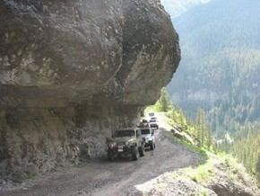
It crosses a ridge connecting Ouray, Colorado with Telluride, Colorado, and is the highest mountain pass in the San Juan Mountains, and the second highest vehicular mountain crossing in Colorado. The road is accessible by four wheel drive vehicles, and is not for the novice driver.
From Ouray, the road turns off the road to Yankee Boy Basin above the Camp Bird Mine near the ghost town of Sneffels southwest of Ouray, and climbs through Imogene Basin to the summit.
From Telluride, the road takes off north of downtown and climbs past the ghost town of Tomboy through Savage Basin to the summit.
The first long distance alternating current power line was constructed over Imogene Pass to carry power from the Telluride area to the Camp Bird Mine.
"Fort Peabody" was constructed in 1904 by a local unit of the Colorado National Guard on top of the pass to prevent union miners from crossing during a labor strike.
An annual foot race is held over the pass between Ouray and Telluride on the first Saturday following Labor Day. This gruelling race starts at around 7800 ft (2377 m), is 17 miles (27.3 km) in length, and crests on the pass at 13,114 ft (3997 m), a change in elevation of just over a mile.