
3-digit postal code prefix 551 Local time Friday 8:19 PM | Time zone WAT (UTC+1) Area 1,961 km² | |
 | ||
Weather 31°C, Wind S at 11 km/h, 58% Humidity | ||
Agbokim water fall ikom cross river state nigeria
Ikom is a Local Government Area of Cross River State, Nigeria. Its headquarters are in the town of Ikom in the east of the area on the Cross River and the A4 highway at5°57′40″N 8°42′39″E.
Contents
- Agbokim water fall ikom cross river state nigeria
- Map of Ikom Nigeria
- Deplorable condition of calabar ikom fed highway cross rivers state
- References
Map of Ikom, Nigeria
It has an area of 1,961 km² and a population of 162,383 at the 2006 census.
The people of Ikom are majorly farmers. Ikom is a major producer of Banana and Plantain for the Nigerian market.
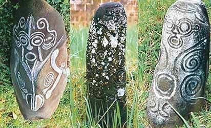
Ikom is known for the Ikom monoliths, artifacts that bear an ancient writing sometimes taken to be an early form of nsibidi.
The postal code of the area is 551.
Deplorable condition of calabar ikom fed highway cross rivers state
References
Ikom Wikipedia(Text) CC BY-SA