
Country Founded 1780s | Area 4.6 km2 | |
 | ||
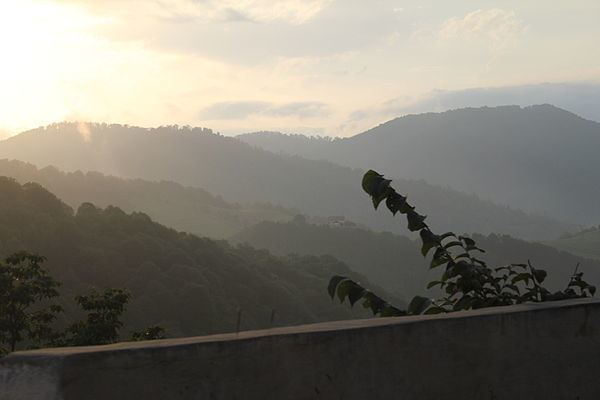
Map of Ijevan
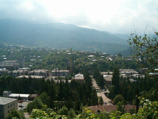
Ijevan (Armenian: Իջևան), is a town in Armenia and the administrative centre of the Tavush Province. It is located at the center of the region, at the foot of Ijevan and Nalteket ridges of Gugark mountains, on the shores of Aghstev River. As of the 2011 census, the population of the town was 21,081, making it the most populated town in the province. As per the 2016 official estimate, the population of Ijevan is around 20,700.
Contents
- Map of Ijevan
- Gigulya ijevan
- Etymology
- History
- Geography and climate
- Population
- Culture
- Transportation
- Industry
- Tourism
- Education
- Sport
- Sister cities
- References
Ijevan is located 137 km northeast of Yerevan. The Yerevan-Tbilisi highway passes through Ijevan.
The town's current name Ijevan, and its former name Karavansara (lasted until 1919), both mean "inn" (caravanserai), in Armenian and Persian, respectively.
Gigulya ijevan
Etymology
The area of modern-day Ijevan used to have many roadside inns known as caravanserais that served travelers between historic Syria and North Caucasus. Starting from the 16th century, the territory was known as Istibulagh (meaning hot fountain in Persian) under the Persian rule . On the same territory, the small village of Karavansara was founded in the 1780s during the Persian rule. However, during the days of the First Republic of Armenia in 1919, the settlement was renamed Ijevan, meaning inn or caravanserai in the Armenian language.։
History
Chamber tombs found at the centre of present-day Ijevan, as well as late Bronze Age cemetery on the left bank of Aghstev river, attest to the early occupation of the site.
Being located on a vital rout of trade between the Levant and Northern Caucasus, the region of present-day Ijevan was home to many rest-houses and caravanserais during the Middle Ages, serving as rest-houses for the passing merchants and their caravans, mainly on the road from Tbilisi to Dvin. The remains of a medieval caravanserai stands on the banks of Aghstev river on a site called Hamam-Jala.
Under the Persian rule, the village of Karavansara was founded during the 1780s. The area of Ijevan along with the territories of present-day Lori Province became part of the Russian Empire, along with neighboring Georgia, as a consequence of the Russo-Persian War of 1804–13. The area became an official region of Russia as per the Treaty of Gulistan signed between Imperial Russia and Qajar Persia in October 1813.
Under the Russian rule, approximately 6,000 Armenian families from Karabakh were allowed to move to the valley of Aghstev river to be resettled in the region of Tavush including the territory of the village of Karavansara. The village witnessed a notable revival during the 1860s and 1870s, as a result of the new road opened between Qazax and Yerevan, passing through Caravansara.
Following the 1918 independence of Armenia, the name of Karavansara was changed to Ijevan in 1919.
On 29 November 1920, Ijevan was the first Armenian settlement where Soviet rule was established after being invaded by the Red Army from Soviet Azerbaijan at the north. In 1930, it became the centre of the newly-formed Ijevan raion. Ijevan was given the status of a town in 1961. In 1970, it was turned into a city of republican sub-ordination.
After the independence of Armenia, Ijevan became the provincial centre of the newly-founded Tavush Province was given as per the administrative reforms of 1995.
Geography and climate
Surrounded with the Gugark mountains, Ijevan is situated in the valley of Aghstev river at an average height of 755 meters above sea level. The surrounding mountains are covered with thick forests, turning into alpine meadows in some areas.
Ijevan is bordered by the village of Getahovit from the north and the village of Gandzakar from the south. A small lake is found at the southern entrance of the town known as Spitak Jur.
This location is classified as Cfa by Köppen and Geiger. The average temperature of the year is 10.6 C, in January 0 C, while in July 21.3 C. The maximum temperature registered ever in Ijevan is +37 C and the minimum is -23. The annual precipitation is 562 mm.
Population
With a population of 20,223 (census2001), Ijevan is the largest urban community of Tavush. There has been no census since 2001. The population has declined considerably since 2001 due to high unemployment and subsequent emigration to Russian Federation.
The majority of Ijevan are ethnic Armenians who belong to the Armenian Apostolic Church. The regulating body of the church is the Diocese of Tavush, headed by Archbishop Yeznik Petrosyan. The Surp Nerses Cathedral in Ijevan is the seat of the diocese.
Here is the population timeline of Ijevan since 1931:
Culture
According to popular tradition, King Artavasdes I built a city on the territory of present-day Ijevan during his reign in the 2nd century BC. He gathered only beautiful girls and handsome boys from all over Armenian regions, so that later they would get married and settle in the newly-established town. Thus, the citizens of modern-day Ijevan are the successors of the handsome generations formed 2000 years ago.
Ijevan was used to host an annual symposium of sculpture between 1985 and 1990 with the presence of many experts from all over the world. Therefore, the residents of Ijevan started to call their town "the city of 100 sculptures". Currently, there are 116 sculptures erected at Ijevan sculptures garden at the centre of the town.
The ethnographic museum of Ijevan was reopened in 1999 while the art gallery was renovated in 2003. The church of Surp Hovhannes is located in the southern part of the town. Another church in Ijevan has been built and financed by an Armenian benefactor from Boston.
Ijevan and the nearby countryside are home to several historic monuments of Armenian Architecture:
Ijevan is a major centre for traditional Armenian handmade rugs and carpets.
The town has its local "Ijevan TV" station.
Transportation
Ijevan is connected with the capital Yerevan and the rest of Armenian territories through the M-4 highway. The highway extends through the Armenia-Azerbaijan border at the northeast of the town.
Domestically, Ijevan is connected with other parts of Tavush through the H-35 Road.
The town used to have a railway station opened at the end of the 19th century. It was an important junction between Erivan and Ganja, Azerbaijan within the Russian Empire. Nowadays, The station is closed with no rail service.
Industry
Ijevan is the economic centre of Tavush. During the Soviet period, the town had witnessed a remarkable industrial progress especially in the field of carpet manufacturing and wood processing. Only one of the Soviet era manufacturing is still operating in Ijevan, this being the Ijevan Wine-Brandy Factory founded in 1951 (particularly famous for its pomegranate wine). The Ijevan carpet weaving mill was the largest in the Caucasus and the 3rd-largest in the whole Soviet Union. After the independence of Armenia, many small industrial plants were founded, including the "Karart" stone processing plant (since 2003).
In 2014, the "Vector" company for software development was opened in Ijevan.
However, unemployment rates remain high in Ijevan and the entire region.
Tourism
Tavush is one of the most picturesque regions in Armenia. Nestled in the valley of Aghstev surrounded with forests and high mountains, Ijevan is more likely a forest-resort. The town did have a 200-bed high-rise hotel built in 1969 on the northern side of the main road which is now in ruins due to vandalism.
The Ijevan Sanctuary is a protected wildlife sanctuary at the west of the town, covering an area of 59 km².
The Yenokavan canyon near the village of Yenokavan village just to the north of Ijevan is among the most visited destinations in the region. It is characterized with beautiful cliffs, caves, forests, rivers and cascades. "Anapat cave" has pre-Christian carvings that resemble Mayan and Aztec works. There are small rest houses and a modern resort in the Yenokavan canyon.
Education
Ijevan is home to 6 public education schools and 3 kindergartens.
The Yerevan State University Ijevan Branch is operating since the 1994-1995 academic year. As of 2016, with more than 700 students, the Ijevan branch has 4 faculties:
Sport
Ijevan is home to the all-seater Arnar Stadium, built in 2007 and hosted the Armenian Independence Cup final match in 2008 for the first and the only time being played outside the capital Yerevan.
FC Bentonit Ijevan was the only professional football club in the town, dissolved in 2007 due to financial difficulties.